

Authentication
--header 'apikey': 'your_secret_apikey'
Authentication is done via request's header. "apikey" parameter should be given at header. Apikeys have daily or monthly or yearly limits and they may not open every product in tarla API.
Base URL: https://world.tarla.io/
Drought
Drought service returns the drought information of given location.
| Base URL | https://world.tarla.io/v3/drought |
| Request Type | GET |
| Response Type | Instant response |
| Sample Request | https://world.tarla.io/v3/drought?lat=39&lng=32&month=2&year=2018 |
Explanation of request parameters:
| Parameter | Type | Explanation |
|---|---|---|
| lat | Float | Latitude |
| lng | Float | Longitude |
| month | Integer | Integer value of month. Between 1-12 |
| year | Integer | Integer value of year. Ex: 2019 |
Explanation of response body parameters:
Successful response body
{
  "drought": {
      "few_drought_possibility": 9.13,
      "moderate_drought_possibility": 5.06,
      "pdsi": -2.396,
      "pdsiInfo": "Orta Kurak",
      "severe_drought_possibility": 2.48,
      "spei12": -0.729,
      "spei12Info": "Hafif Kurak",
      "spei9": -0.8,
      "spei9Info": "Orta Kurak",
      "spi12": -0.148,
      "spi12Info": "Normal",
      "spi6": -0.461,
      "spi6Info": "Normal",
      "total_drought_possibility": 16.67
  }
}
| Parameter | Type | Explanation |
|---|---|---|
| few_drought_possibility | Float | Unit: Percentage % |
| moderate_drought_possibility | Float | Unit: Percentage % |
| pdsi | Float | Palmer drought index. Between -6 and 6 |
| pdsiInfo | String | Explanation of palmer drought index |
| severe_drought_possibility | Float | Unit: Percentage % |
| spei12 | Float | 12 month spei drought index. Between -3 and 3 |
| spei12Info | String | Explanation spei12 |
| spei9 | Float | 9 month spei drought index. Between -3 and 3 |
| spei9Info | String | Explanation spei9 |
| spi12 | Float | 12 month spi drought index. Between -3 and 3 |
| spi12Info | String | Explanation spi12 |
| spi6 | Float | 6 month spi drought index. Between -3 and 3 |
| spi6Info | String | Explanation spi6 |
| total_drought_possibility | Float | Explanation of palmer drought index |
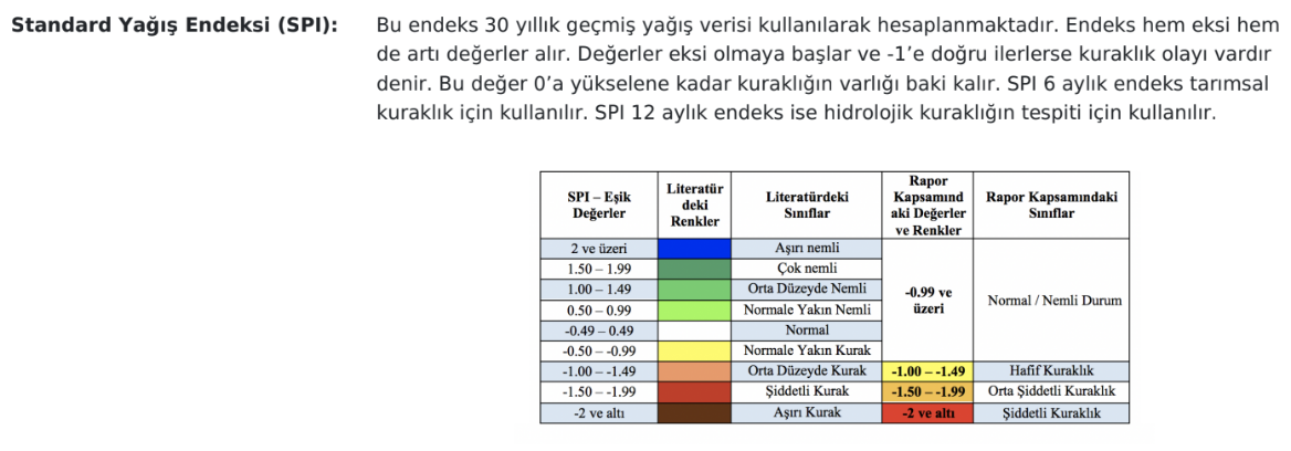
PDSI, SPEI, SPI Tables
Table of PDSI Values
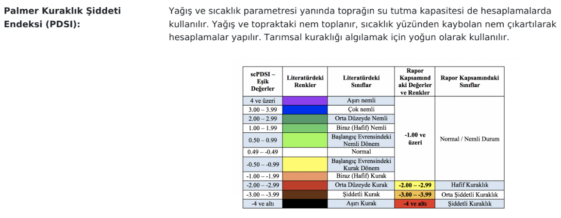
Table of SPEI Values
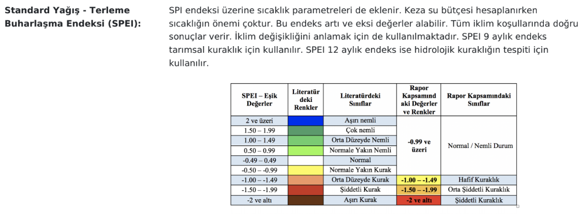
Table of SPI Values
Risk
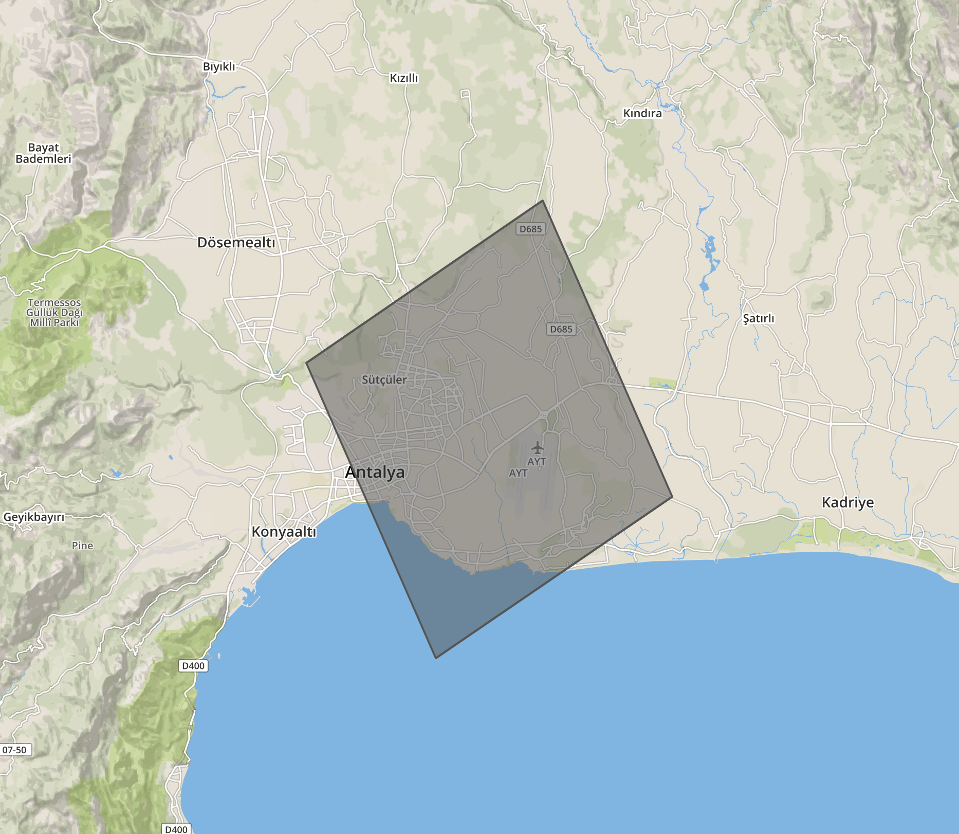
Risk service returns all long term risk parameters (weather and lightning)
for a location. Risk results are returned by grid base. Grid dimension is 12x12 km.
The returning results belong to the grid of the given coordinate. Assuming that the
location is Antalya Airport. The returning result belongs to the grid that includes
Antalya Airport. Number of lightnings and number of polygons indicates the number of events in the grid area.
You can see a grid example at belove image:
| Base URL(v2) | https://world.tarla.io/v2/risk |
| Base URL(v4) | https://world.tarla.io/v4/risk |
| Request Type | GET |
| Response Type | Instant response |
| Sample Request(v2) | https://world.tarla.io/v2/risk?lat=39&lng=32 |
| Sample Request(v4) | https://world.tarla.io/v4/risk?lat=39&lng=32 |
Explanation of request parameters:
| Parameter | Type | Explanation |
|---|---|---|
| lat | Float | Latitude |
| lng | Float | Longitude |
Swagger for risk(v2)
Swagger for risk(v4)
Explanation of response body parameters:
Successful response body
{
  "lat": 39,
  "lng": 32,
  "start_date": "20160501",
  "end_date": "20190315",
  "total_day": 1048,
  "cg_count": 745,
  "ic_count": 215,
  "lightning_risk_count": 4,
  "lightning_risk_count_percent": 0.38,
  "total_precipitation": 852.0,
  "yearly_precipitation": {
          "2016": 134.9,
          "2017": 320.5,
          "2018": 315.0,
          "2019": 81.6
  },
  "total_precip_days": 243,
  "mean_precip_per_day": 0.81,
  "max_precip_day": {
         "value": 19.1,
         "day": "20180329"
  },
  "max_precip_month": {
         "value": 178.2,
         "month": "January"
  },
  "precipitation_90": 6.49,
  "concecutive_precip": 6,
  "concecutive_drought": 105,
  "mean_wind_per_day": 16.63,
  "wind_90": 31.97,
  "max_temp_90": 34.28,
  "max_temp_10": 1.76,
  "min_temp_90": 18.92,
  "min_temp_10": -6.71,
  "max_temp_day": {
        "value": 39.0,
        "day": "20170703"
  },
  "min_temp_day": {
        "value": -14.0,
        "day": "20171228"
  },
  "humudity_90": 84.15,
  "total_gdd_acc": 5639.0,
  "total_dsv_acc": 14.0,
  "total_evapotrans_acc": 921.6,
  "long_term_monthly_precipitation": [
    {
      "month": 4,
      "year": 2018,
      "precipication": 45.5162
    },
    {
      "month": 5,
      "year": 2018,
      "precipication": 27.5539
    },
    {
      "month": 6,
      "year": 2018,
      "precipication": 8.1739
    },
    {
      "month": 7,
      "year": 2018,
      "precipication": 2.3142
    },
    {
      "month": 8,
      "year": 2018,
      "precipication": 2.1591
    },
    {
      "month": 9,
      "year": 2018,
      "precipication": 13.4742
    },
    {
      "month": 10,
      "year": 2018,
      "precipication": 48.2449
    },
    {
      "month": 11,
      "year": 2018,
      "precipication": 105.1477
    },
    {
      "month": 12,
      "year": 2018,
      "precipication": 145.3067
    },
    {
      "month": 1,
      "year": 2019,
      "precipication": 141.0835
    },
    {
      "month": 2,
      "year": 2019,
      "precipication": 105.6716
    },
    {
      "month": 3,
      "year": 2019,
      "precipication": 80.2739
    },
    {
      "month": 4,
      "year": 2019,
      "precipication": 45.5162
    }
  ],
  "prevailing_wind_directions": { // only in version 4. This parameter is not included in version 3 !!
    "north": 0,
    "north_east": 36,
    "east": 28,
    "south_east": 32,
    "south": 188,
    "south_west": 106,
    "west": 238,
    "north_west": 881
  },
  "monthly_risks": {
    "January": {
      "month_count": 3,
      "avarage_cg": 0.67,
      "avarage_ic": 0.33,
      "low_polygon": 0,
      "medium_polygon": 0,
      "high_polygon": 0,
      "precipitation": 178.2,
      "gdd": 36,
      "dsv": 0,
      "evapotrans_acc": 80.8,
      "total_wind_north": 0, // only in version 4.
      "total_wind_north_east": 3, // only in version 4.
      "total_wind_east": 0, // only in version 4.
      "total_wind_south_east": 2, // only in version 4.
      "total_wind_south": 22, // only in version 4.
      "total_wind_south_west": 25, // only in version 4.
      "total_wind_west": 14, // only in version 4.
      "total_wind_north_west": 46 // only in version 4.
    },
    "February": {
      "month_count": 3,
      "avarage_cg": 0.67,
      "avarage_ic": 0.33,
      "low_polygon": 0,
      "medium_polygon": 0,
      "high_polygon": 0,
      "precipitation": 178.2,
      "gdd": 36,
      "dsv": 0,
      "evapotrans_acc": 80.8,
      "total_wind_north": 0, // only in version 4.
      "total_wind_north_east": 3, // only in version 4.
      "total_wind_east": 0, // only in version 4.
      "total_wind_south_east": 2, // only in version 4.
      "total_wind_south": 22, // only in version 4.
      "total_wind_south_west": 25, // only in version 4.
      "total_wind_west": 14, // only in version 4.
      "total_wind_north_west": 46 // only in version 4.
    },
    "March": {
      "month_count": 3,
      "avarage_cg": 0.67,
      "avarage_ic": 0.33,
      "low_polygon": 0,
      "medium_polygon": 0,
      "high_polygon": 0,
      "precipitation": 178.2,
      "gdd": 36,
      "dsv": 0,
      "evapotrans_acc": 80.8,
      "total_wind_north": 0, // only in version 4.
      "total_wind_north_east": 3, // only in version 4.
      "total_wind_east": 0, // only in version 4.
      "total_wind_south_east": 2, // only in version 4.
      "total_wind_south": 22, // only in version 4.
      "total_wind_south_west": 25, // only in version 4.
      "total_wind_west": 14, // only in version 4.
      "total_wind_north_west": 46 // only in version 4.
    },
    "April": {
      "month_count": 3,
      "avarage_cg": 0.67,
      "avarage_ic": 0.33,
      "low_polygon": 0,
      "medium_polygon": 0,
      "high_polygon": 0,
      "precipitation": 178.2,
      "gdd": 36,
      "dsv": 0,
      "evapotrans_acc": 80.8,
      "total_wind_north": 0, // only in version 4.
      "total_wind_north_east": 3, // only in version 4.
      "total_wind_east": 0, // only in version 4.
      "total_wind_south_east": 2, // only in version 4.
      "total_wind_south": 22, // only in version 4.
      "total_wind_south_west": 25, // only in version 4.
      "total_wind_west": 14, // only in version 4.
      "total_wind_north_west": 46 // only in version 4.
    },
    "May": {
      "month_count": 3,
      "avarage_cg": 0.67,
      "avarage_ic": 0.33,
      "low_polygon": 0,
      "medium_polygon": 0,
      "high_polygon": 0,
      "precipitation": 178.2,
      "gdd": 36,
      "dsv": 0,
      "evapotrans_acc": 80.8,
      "total_wind_north": 0, // only in version 4.
      "total_wind_north_east": 3, // only in version 4.
      "total_wind_east": 0, // only in version 4.
      "total_wind_south_east": 2, // only in version 4.
      "total_wind_south": 22, // only in version 4.
      "total_wind_south_west": 25, // only in version 4.
      "total_wind_west": 14, // only in version 4.
      "total_wind_north_west": 46 // only in version 4.
    },
    "June": {
      "month_count": 3,
      "avarage_cg": 0.67,
      "avarage_ic": 0.33,
      "low_polygon": 0,
      "medium_polygon": 0,
      "high_polygon": 0,
      "precipitation": 178.2,
      "gdd": 36,
      "dsv": 0,
      "evapotrans_acc": 80.8,
      "total_wind_north": 0, // only in version 4.
      "total_wind_north_east": 3, // only in version 4.
      "total_wind_east": 0, // only in version 4.
      "total_wind_south_east": 2, // only in version 4.
      "total_wind_south": 22, // only in version 4.
      "total_wind_south_west": 25, // only in version 4.
      "total_wind_west": 14, // only in version 4.
      "total_wind_north_west": 46 // only in version 4.
    },
    "July": {
      "month_count": 3,
      "avarage_cg": 0.67,
      "avarage_ic": 0.33,
      "low_polygon": 0,
      "medium_polygon": 0,
      "high_polygon": 0,
      "precipitation": 178.2,
      "gdd": 36,
      "dsv": 0,
      "evapotrans_acc": 80.8,
      "total_wind_north": 0, // only in version 4.
      "total_wind_north_east": 3, // only in version 4.
      "total_wind_east": 0, // only in version 4.
      "total_wind_south_east": 2, // only in version 4.
      "total_wind_south": 22, // only in version 4.
      "total_wind_south_west": 25, // only in version 4.
      "total_wind_west": 14, // only in version 4.
      "total_wind_north_west": 46 // only in version 4.
    },
    "August": {
      "month_count": 3,
      "avarage_cg": 0.67,
      "avarage_ic": 0.33,
      "low_polygon": 0,
      "medium_polygon": 0,
      "high_polygon": 0,
      "precipitation": 178.2,
      "gdd": 36,
      "dsv": 0,
      "evapotrans_acc": 80.8,
      "total_wind_north": 0, // only in version 4.
      "total_wind_north_east": 3, // only in version 4.
      "total_wind_east": 0, // only in version 4.
      "total_wind_south_east": 2, // only in version 4.
      "total_wind_south": 22, // only in version 4.
      "total_wind_south_west": 25, // only in version 4.
      "total_wind_west": 14, // only in version 4.
      "total_wind_north_west": 46 // only in version 4.
    },
    "September": {
      "month_count": 3,
      "avarage_cg": 0.67,
      "avarage_ic": 0.33,
      "low_polygon": 0,
      "medium_polygon": 0,
      "high_polygon": 0,
      "precipitation": 178.2,
      "gdd": 36,
      "dsv": 0,
      "evapotrans_acc": 80.8,
      "total_wind_north": 0, // only in version 4.
      "total_wind_north_east": 3, // only in version 4.
      "total_wind_east": 0, // only in version 4.
      "total_wind_south_east": 2, // only in version 4.
      "total_wind_south": 22, // only in version 4.
      "total_wind_south_west": 25, // only in version 4.
      "total_wind_west": 14, // only in version 4.
      "total_wind_north_west": 46 // only in version 4.
    },
    "October": {
      "month_count": 3,
      "avarage_cg": 0.67,
      "avarage_ic": 0.33,
      "low_polygon": 0,
      "medium_polygon": 0,
      "high_polygon": 0,
      "precipitation": 178.2,
      "gdd": 36,
      "dsv": 0,
      "evapotrans_acc": 80.8,
      "total_wind_north": 0, // only in version 4.
      "total_wind_north_east": 3, // only in version 4.
      "total_wind_east": 0, // only in version 4.
      "total_wind_south_east": 2, // only in version 4.
      "total_wind_south": 22, // only in version 4.
      "total_wind_south_west": 25, // only in version 4.
      "total_wind_west": 14, // only in version 4.
      "total_wind_north_west": 46 // only in version 4.
    },
    "November": {
      "month_count": 3,
      "avarage_cg": 0.67,
      "avarage_ic": 0.33,
      "low_polygon": 0,
      "medium_polygon": 0,
      "high_polygon": 0,
      "precipitation": 178.2,
      "gdd": 36,
      "dsv": 0,
      "evapotrans_acc": 80.8,
      "total_wind_north": 0, // only in version 4.
      "total_wind_north_east": 3, // only in version 4.
      "total_wind_east": 0, // only in version 4.
      "total_wind_south_east": 2, // only in version 4.
      "total_wind_south": 22, // only in version 4.
      "total_wind_south_west": 25, // only in version 4.
      "total_wind_west": 14, // only in version 4.
      "total_wind_north_west": 46 // only in version 4.
    },
    "December": {
      "month_count": 3,
      "avarage_cg": 0.67,
      "avarage_ic": 0.33,
      "low_polygon": 0,
      "medium_polygon": 0,
      "high_polygon": 0,
      "precipitation": 178.2,
      "gdd": 36,
      "dsv": 0,
      "evapotrans_acc": 80.8,
      "total_wind_north": 0, // only in version 4.
      "total_wind_north_east": 3, // only in version 4.
      "total_wind_east": 0, // only in version 4.
      "total_wind_south_east": 2, // only in version 4.
      "total_wind_south": 22, // only in version 4.
      "total_wind_south_west": 25, // only in version 4.
      "total_wind_west": 14, // only in version 4.
      "total_wind_north_west": 46 // only in version 4.
    },
  }
}
| Parameter | Type | Explanation |
|---|---|---|
| lat | Float | Float |
| lng | Float | Float |
| start_date | String | Start date of calculation of returning risk parameters. |
| end_date | String | End date of calculation of returning risk parameters. |
| total_day | Integer | Indicates that for how many days these risk parameters are calculated. (end_date - start_date) |
| cg_count | Integer | Total cloud to ground lightning count in the 12x12km grid. |
| ic_count | Integer | Total inter cloud lightning count in the 12x12km grid. |
| lightning_risk_count | Integer | Number of risky days that can happen hail etc. Number of days that have cg/ic < 0.1 |
| lightning_risk_count_percent | Float | Percentage of lightning risks in total days |
| total_precipitation | Float | Total precipitation. Unit milimeter. |
| yearly_precipitation | JSON | Total precipitation for each year in a given time interval. Unit milimeter. |
| total_precip_days | Integer | How many days passed with precipitation in given time interval. |
| mean_precip_per_day | Float | Average precipitation for one day in given time interval. |
| max_precip_day | JSON | Indicates the day that has maximum precipitation for given time interval. |
| max_precip_month | JSON | Indicates the month that has maximum precipitation for given time interval. |
| precipitation_90 | Float | Extreme precipitation average that is above 90 percent when values are sorted in ascending order. |
| concecutive_precip | Integer | Indicates how many consecutive 5 days precipitation happened. |
| concecutive_drought | Integer | Indicates how many consecutive 5 days drougth(no precipitation) happened. |
| mean_wind_per_day | Float | Average wind speed for one day in given time interval. Unit km/h |
| wind_90 | Float | Extreme wind speed average that is above 90 percent when values are sorted in ascending order. |
| max_temp_90 | Float | Extreme maximum temperature average that is above 90 percent when values are sorted in ascending order. |
| max_temp_10 | Float | Extreme maximum temperature average that is belove 10 percent when values are sorted in ascending order. |
| min_temp_90 | Float | Extreme minimum temperature average that is above 90 percent when values are sorted in ascending order. |
| min_temp_10 | Float | Extreme minimum temperature average that is belove 10 percent when values are sorted in ascending order. |
| max_temp_day | JSON | Indicates the day that has maximum temperature for given time interval |
| min_temp_day | JSON | Indicates the day that has minimum temperature for given time interval |
| humudity_90 | Float | Extreme humidity average that is above 90 percent when values are sorted in ascending order. Unit percentage % |
| total_gdd_acc | Float | Temperature accumulation in given time interval. Unit celcius |
| total_dsv_acc | Float | Disease risk accumulation in given time interval. Unitless |
| total_evapotrans_acc | Float | Sweating evaporation accumulation in given time interval. Unit milimeter. |
| long_term_monthly_precipitation | JSON | Average precipitations are calculated from approximately 30 years of data starting from the given year. |
| prevailing_wind_directions | JSON | Indicates prevailing wind directions in given location. It is calculated between start and end dates. It includes 8 directions. |
| monthly_risks | JSON | Risk parameters for months |
Explanation of long_term_monthly_precipitation JSON:
| Parameter | Type | Explanation |
|---|---|---|
| month | Integer | Integer value of month. Between 1-12 |
| year | Integer | Integer value of year. Ex: 2019 |
| precipitation | Float | Average precipitation for this date calculated from ~30 years of data. |
Explanation of monthly_risks JSON:
| Parameter | Type | Explanation |
|---|---|---|
| month_count | Integer | Indicates how many month there are in given time interval |
| avarage_cg | Float | Average cloud to ground lightning that happened in this month.(in 12x12km grid) |
| avarage_ic | Float | Average inter cloud lightning that happened in this month.(in 12x12km grid) |
| low_polygon | Integer | Number of low (few) storm polygon that happened in this month.(in 12x12km grid) |
| medium_polygon | Integer | Number of medium (moderate) storm polygon that happened in this month.(in 12x12km grid) |
| high_polygon | Integer | Number of high (severe) storm polygon that happened in this month.(in 12x12km grid) |
| precipitation | Float | Total precipitation in this month. Unit milimeter. |
| gdd | Float | Temperature accumulation in this month. Unit celcius |
| dsv | Float | Disease risk accumulation in this month. Unitless |
| evapotrans_acc | Float | Sweating evaporation accumulaiton in this month. Unit milimeter |
| total_wind_north total_wind_north_east total_wind_east total_wind_south_east total_wind_south total_wind_south_west total_wind_west total_wind_north_west |
Integer | It indicates that how many times the wind blow from this direction in this month. Lets say report's start date is 2019-01-01 and end date is 2020-12-01 then it means there are 62 days for the month January. If total_wind_north is 20 in month January it means that wind blows in north direction 20 days out of 62. |
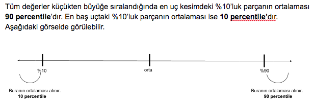
Explanation of percentile:
Explanation of consecutive precip, drought:
Returns the number of series of 5 consecutive days with precipitation. The array given below shows the amount of precipitation and the number of consecutive_precip.
Precipitation Array: [0, 0, 1.2, 2.3, 0.5, 0, 1.3, 1.5, 2.5, 3.1, 2.6, 4.2, 5.3, 0, 0, 1.2, 3.1, 4.2, 5.3, 1 ]
Consecutive_precip: 2
Explanation of month count:
Returns number of months between the given time interval. The example is shown below.
start_date: 20180301
end_date: 20190530
There is 1 consecutive months of the year and an extra 2 March, April and May, such as March in 2018 and 2019, within the time period given above
Risk Score
| Base URL | https://world.tarla.io/v1.0/risks/risk |
| Request Type | GET |
| Response Type | Instant response |
| Sample Request | https://world.tarla.io/v1.0/risks/risk?polygon-geometry=POLYGON((26.800%2040.888,26.836%2040.888,26.836%2040.968,26.800%2040.968,26.800%2040.888))&start=2019-06-01&end=2019-06-10 |
Explanation of request parameters:
| Parameter | Type | Explanation |
|---|---|---|
| polygon-geometry | Object | Geojson object of the area for search. This geometry can be extracted via TKGM by the user. |
| start | String | Start date |
| end | String | End date |
Explanation of response body parameters:
Successful response body
{
          "risk": {
            "2019-06-01": 0.28,
            "2019-06-02": 0.28,
            "2019-06-03": 0.27,
            "2019-06-04": 0.25,
            "2019-06-05": 0.26,
            "2019-06-06": 0.27,
            "2019-06-07": 0.29,
            "2019-06-08": 0.29,
            "2019-06-09": 0.32,
            "2019-06-10": 0.34
          }
        }
| Parameter | Type | Explanation |
|---|---|---|
| product | List | Product that is returned. |
| date | String | Date (YYYY-MM-DD) of the satellite output that is returned. |
| value | Float | Returns risk score of subject date for 1km. |
Wheat Yield
| Base URL | https://world.tarla.io/v1.0/risks/wheat |
| Request Type | GET |
| Response Type | Instant response |
| Sample Request | https://world.tarla.io/v1.0/risks/wheat?city-region=tekirdag-malkara&start=2017&end=2018 |
Explanation of request parameters:
| Parameter | Type | Explanation |
|---|---|---|
| city-region | String | Related city region information |
| start | String | Start date (YYYY) |
| end | String | End date (YYYY) |
Explanation of response body parameters:
Successful response body
{
          "wheat": [
            {
              "date": "2007",
              "value": 369.1
            },
            {
              "date": "2008",
              "value": 369.2
            },
            {
              "date": "2009",
              "value": 347.4
            },
            {
              "date": "2010",
              "value": 365.6
            }
          ]
        }
| Parameter | Type | Explanation |
|---|---|---|
| product | List | Product that is returned. |
| date | String | Date (YYYY) of the satellite output that is returned. |
| value | Float | Returned yield data for that date. |
Soil Moisture
| Base URL | https://world.tarla.io/v1.0/risks/soil_moisture |
| Request Type | GET |
| Response Type | Instant response |
| Sample Request | https://world.tarla.io/v1.0/risks/soil_moisture?polygon-geometry=POLYGON((26.800%2040.888,26.836%2040.888,26.836%2040.968,26.800%2040.968,26.800%2040.888))&start=2019-06-01&end=2019-06-10 |
Explanation of request parameters:
| Parameter | Type | Explanation |
|---|---|---|
| polygon-geometry | Object | Geojson object of the area for search. This geometry can be extracted via TKGM by the user. |
| start | String | Start date |
| end | String | End date |
Explanation of response body parameters:
Successful response body
{
          "soil_moisture": {
            "2019-06-01": 0.19,
            "2019-06-02": 0.19,
            "2019-06-03": 0.19,
            "2019-06-04": 0.19,
            "2019-06-05": 0.20,
            "2019-06-06": 0.19,
            "2019-06-07": 0.19,
            "2019-06-08": 0.19,
            "2019-06-09": 0.19,
            "2019-06-10": 0.19
          }
        }
| Parameter | Type | Explanation |
|---|---|---|
| product | List | Product that is returned. |
| date | String | Date (YYYY-MM-DD) of the satellite output that is returned. |
| value | Float | Returns soil moisture of subject date for 1km. |
Nowcast
Nowcast
Nowcast service sends you an alert for lightning, precipitation or storm polygon events.
This URL is to include a user to nowcast service. When an alert is happening in the user's location,
we POST a JSON to URL that is specified when including the user. We send all users at once, not one by one.
If no alert alert has happened in any of your user's location, we do not POST anything.
Therefore, to use this service, you need an API that accepts our POST requests.
Then you can put URL of your API when you are adding new user under post_url parameter.
Nowcast service checks all coordinates approximately every 5 minutes. If it detects any lightning, precipitation or storm polygon, it sends alerts. When an alert is sent to the user, 1 hour sleep time begins. It means that we do not send same alert type for that user for 1 hour. Assume that the system sends a lightning alert to user X. Then it does not send any lightning alert for that user for 1 hour. However, if precipitation alert happens in user X's location, system sends it.
| Base URL | https://world.tarla.io/v1/alert |
| Request Type | POST |
| Request Heeader | application/json |
| Response Type | Instant response |
{
  "lat": 39.12,
  "lng": 32.23,
  "post_url": "http://sample-backend.com/nowcast",
  "post_auth": "Bearer eyJhbGciOiJIUzI1NiIsInR5cCI6IkpXVCJ9.eyJzdWIiOiIxMjM0NTY3ODkwIiwibmFtZSI6IkpvaG4gRG9lIiwiaWF0IjoxNTE2MjM5MDIyfQ.SflKxwRJSMeKKF2QT4fwpMeJf36POk6yJV_adQssw5c",
  "post_user_id": "123456",
  "alert_group_id": 2,
  "is_tarlaio_content": true,
  "plant_id": 1,
  "prefix": "prefix for tarlaio content",
  "postfix": "postfix for tarlaio content",
  "forecast_hourly_rules": [
                             {"rules":{"precipitation": [20, 50]},
                              "content": "Strong Precipitation"},
                              {"rules":{"precipitation": [100, "up"]},
                              "content": "Very Strong Precipitation"},
                              {"rules":{"windspeed": [62, 74]},
                              "content": "Storm"}]

}
| Parameter | Type | Explanation |
|---|---|---|
| lat | Float | Latitude of user's coordinate. |
| lng | Float | Longitude of user's coordinate. |
| post_url | String | It is the POST URL when an alert happens in user's location. (You need to give same POST URL for all of your users. By this way, we can send all users that has alerts to your URL at once.) |
| post_auth | String | Optional. It is for security. When our system POST nowcast alerts to your post_url, this value is sent as value of Authorization header parameter. If you don't want, just send blank "" |
| post_user_id | String | Unique id of the user in your system. |
| alert_group_id | Integer | Optional. If you want custom sleep times or custom texts you should send your id here. Id is provided by tarla.io technical support team via email. |
| is_tarlaio_content | Boolean | Optional. If you want to get daily agriculture content notification system of tarla.io set this as True. |
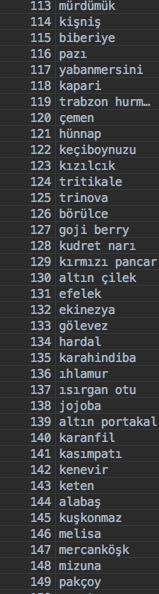
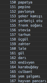
| plant_id | Integer | Optional. tarla.io agriculture notification system based on plants so we need plant_id of the user. You can see the plant id list below. However if you just want to get content about weather and general agriculture tricks you can send plant_id as null or send is_tarlaio_content as true and not send plant_id parameter. |
| prefix | String | Optional. Set, If you want prefix text before tarlaio contents. |
| postfix | String | Optional. Set, If you want postfix text before tarlaio contents. |
| forecast_hourly_rules | List | Optional. If you want custom forecast for next day, you should define rules here. For one user you can define multiple rules. For every rule you should give "rules" and "content" parameter. If rule happens you get json post with given "content" parameter. Rule schema can be like this {"precipitation": [20, 50]} (means between 20-50) or {"precipitation": ["down", 50]} (means below 50) or {"precipitation": [20, "up"]} (means bigger than 20). |
{
  "result":"successful"
}
Explanation of alert POST body parameters:
This is explanation of a sample alert POST request to your API.
{
  "lightnings": [
    {
      "user_id": "sample_user_id",
      "lat": 39.19,
      "lng": 32.12,
      "distance": 7.97
    },
    {
      "user_id": "sample_user_id_2",
      "lat": 40.22,
      "lng": 28.11,
      "distance": 11.84
    }
  ],
  "polygons": [
    {
      "user_id": "sample_user_id",
      "severity": "High"
    },
    {
      "user_id": "sample_user_id",
      "severity": "Medium"
    }
  ],
  "precipitations": [
    {
      "user_id": "sample_user_id",
      "direction": "north",
      "dbz": 23,
      "arrival_time": 25,
      "type": "rain"
    },
    {
      "user_id": "sample_user_id_2",
      "direction": "northeast",
      "dbz": 33,
      "arrival_time": 30,
      "type": "snow"
    }
  ],
  "weather_alerts": [
    {
      "user_id": "sample_user_id",
      "content": "Strong Storm",
      "time_list": ["2021-05-25 15:00"]
    },
    {
      "user_id": "sample_user_id",
      "content": "Strong Precipitation",
      "time_list": ["2021-05-25 15:00"]
    },
    {
      "user_id": "sample_user_id_2",
      "content": "Strong Precipitation",
      "time_list": ["2021-05-24 01:00", "2021-05-24 03:00", "2021-05-24 05:00"]
    }
  ],
  "tarlaio": [
    {
      "user_id": "sample_user_id",
      "content": "Your predefined content when setting weather conditions."
    },
    {
      "user_id": "sample_user_id_2",
      "content": "Your predefined content when setting weather conditions."
    }
  ]
}
lightnings parameter explanations:
| Parameter | Type | Explanation |
|---|---|---|
| user_id | String | Id of the user that has lightning near. |
| lat | Float | Latitude of the nearest lightning. |
| lng | Float | Longitude of the nearest lightning. |
| distance | Float | Distance of the nearest lightning to user's location. Unit: km |
polygons parameter explanations:
| Parameter | Type | Explanation |
|---|---|---|
| user_id | String | Id of the user that has storm polygon near. |
| severity | String | It indicates the severity of the storm polygon. It can be "High", "Medium" or "Low". |
precipitations parameter explanations:
| Parameter | Type | Explanation |
|---|---|---|
| user_id | String | Id of the user that has precipitation approaching to his location. |
| direction | String | Direction of the approaching precipitation. It can be "north", "south", "west", "east", "northeast", "northwest", "southeast", "southwest" |
| dbz | Integer | Radar DBZ value of the approaching precipitation. |
| arrival_time | Integer | Approximate arrival time of the approaching precipitation. Unit: minute |
| type | String | Type of the precipitation. It can be "snow" or "rain". |
IMPORTANT NOTE: There are 2 types of approaching precipitation. First one has arrival time and second one has no arrival time. Second one actually does not mean an approaching precipitation. It just says that, you have precipitation clouds near by you be careful. They can come to your location or go away. This type of precipitation has arrival_time parameter as None.
weather_alerts parameter explanations:
| Parameter | Type | Explanation |
|---|---|---|
| user_id | String | Id of the user that has weather forecast alert in his location. |
| content | String | It is the text while you were setting the weather rules conditions. If conditions happen, this content parameter is posted in json. |
| time_list | List | It is the time list indicates that this forecast will happen. It is in UTC time. |
tarlaio parameter explanations:
| Parameter | Type | Explanation |
|---|---|---|
| user_id | String | Id of the user that has tarlaio alert in his location. |
| content | String | It is the text that is created by tarlaio system. It includes dynamic or static information about agriculture. |
Nowcast Delete
You can remove nowcast user from system. You can just remove your users, even another customer has same user gsm with you, system just deletes your user and do not touch other customer's user.
| Base URL | https://world.tarla.io/v1/alert |
| Request Type | DELETE |
| Request Heeader | application/json |
| Response Type | Instant response |
{
 "post_url": "http://sample-backend.com/nowcast",
 "post_user_id": "123456"
}
Nowcast Current
This returns if any lightning, polygon or precipitation events occurs at given location in last 10 minutes. It returns distance and location of the lightning. It also returns precipitation in mm beside radar dbz score of the precipitation cloud. Returns data within 20 km radius of the location sent as a parameter.
| Base URL | https://world.tarla.io/v1/nowcast/current |
| Request Type | GET |
| Response Type | Instant response |
| Sample Request | https://world.tarla.io/v1/nowcast/current?lat=38.344531&lng=33.751179 |
| Parameter | Type | Explanation |
|---|---|---|
| lat | Float | Latitude of wanted location. |
| lng | Float | Longitude of wanted location. |
Explanation of response body parameters:
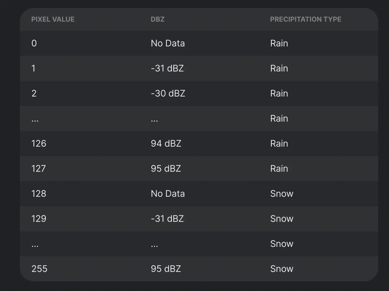
Adjusted Dbz Range
Successful response body
{
    "precipitations": [
        {
            "adjusted_dbz": 81,
            "precipitation_type": "rain",
            "precipitation_distance": 0,
            "lat": 38.47114,
            "lng": 35.805,
            "polygon_wkt": "POLYGON((35.79000000000003 38.4887513544519 ...))"
        }
    ],
    "lightnings": [
        {
            "type": "1",
            "lat": 38.48368,
            "lng": 35.79916,
            "distance": 0.59,
            "current": -2340,
            "height": 14088
        }
    ],
    "polygons": [
        {
            "identifier": "EU202209211404001",
            "creation_time": "2022-09-21T17:21:15.994755",
            "expire_time": "2022-09-21T17:50:00",
            "effective_time": "2022-09-21T17:05:00",
            "severity": "Unknown",
            "distance": 0,
            "direction": 209,
            "relative_direction": 222,
            "speed": 2,
            "cell_polygon_wkt": "POLYGON((35.741219 38.416540 ...))",
            "polygon_wkt": "POLYGON((35.7392106235694 38.4316028687595 ...))"
        }
    ]
}
| Titles | Contents | ||||||||||||||||||||||||||||||||||||
|---|---|---|---|---|---|---|---|---|---|---|---|---|---|---|---|---|---|---|---|---|---|---|---|---|---|---|---|---|---|---|---|---|---|---|---|---|---|
| precipitations |
|
||||||||||||||||||||||||||||||||||||
| lightnings |
|
||||||||||||||||||||||||||||||||||||
| polygons |
|
Relative Direction Explanation
The relative direction between the coordinates sent and the center coordinates of the region where the weather events occur is the geometric degree representation.

There is about 20 degree between given parameters and nowcast event area.

There is about 225 degree between given parameters and nowcast event area.
Weather
Weather Daily
It returns 7-day forward weather data starting from current date.
| Base URL | https://world.tarla.io/v3/weather/daily |
| Request Type | GET |
| Response Type | Instant response |
| Sample Request | https://world.tarla.io/v3/weather/daily?lat=39&lng=32 |
Explanation of response body parameters:
Successful response body
{
  "daily": [
    {
      "time": "2019-08-27",
      "icon": 1,
      "temperature_max": 30.64,
      "temperature_min": 16.64,
      "precipitation": 0.0,
      "precipitation_probability": 0,
      "humidity": 36,
      "windspeed": 17.39,
      "winddirection": 0
    },
    .
    .
    .
]}
| Parameter | Type | Explanation |
|---|---|---|
| time | String | Date in YYYY-MM-DD format. Ex: "2019-08-27" |
| humidity | Integer | Unit: Percentage % |
| precipitation | Float | Unit: Milimeter |
| precipitation_probability | Integer | Unit: Percentage % |
| temperature_max | Float | Maximum temperature for that day. Unit: Celcius |
| temperature_min | Float | Minimum temperature for that day. Unit: Celcius |
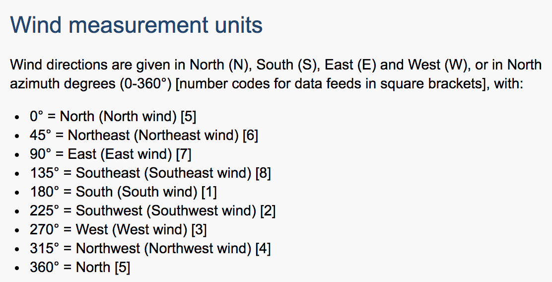
| winddirection | Integer | Direction of the wind 0-360 degree. Explanation is belove. |
| windspeed_max | Float | Maximum wind speed. Unit: km/h |
| icon | Integer | Weather icon number between 1-17. 1- Güneşli 2- Güneşli-Bulutlu 3- Parçalı Bulutlu 4- Kapalı 5- Sisli 6- Yağmurlu 7- Sağanak Yağışlı 8- Şimşekli-Yağmurlu 9- Karlı 10- Sağanak Karlı 11- Sulu kar 12- Yağmurlu 13- Hafif Karlı 14- Parçalı Yağmurlu 15- Rüzgarlı Karlı 16- Hafif Yağmurlu 17- Hafif Karlı |
Explanation of winddirection parameter:
Weather Monthly
It returns 14-day forward and 14-day backward weather data starting from current date. So total 29 days will be returned.
| Base URL | https://world.tarla.io/v3/weather/month |
| Request Type | GET |
| Response Type | Instant response |
| Sample Request | https://world.tarla.io/v3/weather/month?lat=39&lng=32 |
Explanation of response body parameters:
Successful response body
{
  "weather": [
    {
      "dt": 20200702,
      "humidity": 49,
      "precipitation": 0.0,
      "precipitation_probability": 0,
      "temperature_max": 35.46,
      "temperature_min": 26.77,
      "winddirection": 45,
      "windspeed": 14.69,
      "icon": 1
    },
    .
    .
    .
]}
| Parameter | Type | Explanation |
|---|---|---|
| dt | Integer | Date in YYYYMMDD format. Ex: "20190827" |
| humidity | Integer | Unit: Percentage % |
| precipitation | Float | Unit: Milimeter |
| precipitation_probability | Integer | Unit: Percentage % |
| temperature_max | Float | Maximum temperature for that day. Unit: Celcius |
| temperature_min | Float | Minimum temperature for that day. Unit: Celcius |
| winddirection | Integer | Direction of the wind 0-360 degree. Explanation is belove. |
| windspeed_max | Float | Maximum wind speed. Unit: km/h |
| icon | Integer | Weather icon number between 1-17. 1- Güneşli 2- Güneşli-Bulutlu 3- Parçalı Bulutlu 4- Kapalı 5- Sisli 6- Yağmurlu 7- Sağanak Yağışlı 8- Şimşekli-Yağmurlu 9- Karlı 10- Sağanak Karlı 11- Sulu kar 12- Yağmurlu 13- Hafif Karlı 14- Parçalı Yağmurlu 15- Rüzgarlı Karlı 16- Hafif Yağmurlu 17- Hafif Karlı |
Weather Current
This returns current weather.
| Base URL | https://world.tarla.io/v1/weather/current |
| Request Type | GET |
| Response Type | Instant response |
| Sample Request | https://world.tarla.io/v1/weather/current?lat=39&lng=32 |
Explanation of response body parameters:
Successful response body
{
  "current_weather": {
    "time": "2019-08-15 08:00",
    "icon": 2,
    "temperature": 30.41,
    "precipitation": 0.0,
    "precipitation_probability": 5,
    "humidity": 40,
    "windspeed": 11.92,
    "winddirection": 265
  }
}
| Parameter | Type | Explanation |
|---|---|---|
| time | Timestamp | Date with hour of current in UTC. |
| icon | Integer | Weather icon number between 1-35. 1-Güneşli,2-Açık Hava,3-Açık Hava,4-Az Bulutlu,5-Rüzgar ve Bulutlu,6-Rüzgar ve Bulutlu,7-Parçalı Bulutlu,8-Parçalı Bulutlu,9-Parçalı Bulutlu,10-Fırtına Bulutları,11-Fırtına Bulutları,12-Fırtına Bulutları,13-Puslu,14-Puslu,15-Puslu,16-Sisli,17-Sisli,18-Sisli,19-Çoğunlukla Bulutlu,20-Çoğunlukla Bulutlu,21-Çoğunlukla Bulutlu,22-Bulutlu,23-Yağmurlu,24-Kar Yağışı,25-Sağanak Yağmur,26-Sağanak Kar Yağışı,27-Fırtınalı Yağmur,28-Gök Gürültülü Fırtına,29-Fırtınalı Yağmur,30-Gök Gürültülü Yağmur,31-Sağanak Yağış,32-Sağanak Kar Yağışı,33-Yağmurlu,34-Kar Yağışı,35-Karla Karışık Yağmur |
| temperature | Float | Current temperature. Unit: Celcius |
| precipitation | Float | Unit: Milimeter |
| precipitation_probability | Integer | Unit: Percentage % |
| humidity | Integer | Unit: Percentage % |
| windspeed | Float | Maximum wind speed. Unit: km/h |
| winddirection | Integer | Direction of the wind 0-360 degree. Explanation is belove. |
Explanation of winddirection parameter:
Weather Daily Hourly
This returns weather forecast in daily and hourly format. 7-day daily and 7-day hourly forecast data will be returned.
| Base URL | https://world.tarla.io/v3/weather |
| Request Type | GET |
| Response Type | Instant response |
| Sample Request | https://world.tarla.io/v3/weather?lat=39&lng=32 |
Swagger for weather daily hourly
Explanation of response body parameters:
Successful response body
{
  "daily": [
    {
      "time": "2019-08-19",
      "icon": 2,
      "temperature_max": 25.17,
      "temperature_min": 13.37,
      "precipitation": 0.0,
      "precipitation_probability": 8,
      "humidity": 60,
      "windspeed": 17.46,
      "winddirection": 45
    },
    {
      "time": "2019-08-20",
      "icon": 8,
      "temperature_max": 25.31,
      "temperature_min": 14.82,
      "precipitation": 1.23,
      "precipitation_probability": 34,
      "humidity": 65,
      "windspeed": 18.72,
      "winddirection": 0
    },
    {
      "time": "2019-08-21",
      "icon": 8,
      "temperature_max": 25.93,
      "temperature_min": 14.64,
      "precipitation": 1.2,
      "precipitation_probability": 29,
      "humidity": 66,
      "windspeed": 23.33,
      "winddirection": 315
    },
    {
      "time": "2019-08-22",
      "icon": 1,
      "temperature_max": 27.83,
      "temperature_min": 15.74,
      "precipitation": 0.0,
      "precipitation_probability": 10,
      "humidity": 66,
      "windspeed": 17.78,
      "winddirection": 270
    },
    {
      "time": "2019-08-23",
      "icon": 1,
      "temperature_max": 29.88,
      "temperature_min": 15.75,
      "precipitation": 0.0,
      "precipitation_probability": 0,
      "humidity": 58,
      "windspeed": 15.7,
      "winddirection": 0
    },
    {
      "time": "2019-08-24",
      "icon": 1,
      "temperature_max": 30.97,
      "temperature_min": 16.74,
      "precipitation": 0.0,
      "precipitation_probability": 5,
      "humidity": 47,
      "windspeed": 23.15,
      "winddirection": 45
    },
    {
      "time": "2019-08-25",
      "icon": 1,
      "temperature_max": 30.99,
      "temperature_min": 16.62,
      "precipitation": 0.0,
      "precipitation_probability": 0,
      "humidity": 47,
      "windspeed": 19.33,
      "winddirection": 45
    }
  ],
  "hourly": [
    {
      "time": "2019-08-19 00:00",
      "icon": 13,
      "temperature": 14.99,
      "precipitation": 0.0,
      "precipitation_probability": 0,
      "humidity": 75,
      "windspeed": 13.18,
      "winddirection": 15
    },
    {
      "time": "2019-08-19 01:00",
      "icon": 1,
      "temperature": 14.39,
      "precipitation": 0.0,
      "precipitation_probability": 0,
      "humidity": 77,
      "windspeed": 10.62,
      "winddirection": 9
    },
    {
      "time": "2019-08-19 02:00",
      "icon": 13,
      "temperature": 14.04,
      "precipitation": 0.0,
      "precipitation_probability": 0,
      "humidity": 80,
      "windspeed": 8.89,
      "winddirection": 5
    },
    .
    .
    .
  ]
}
| Parameter | Type | Explanation |
|---|---|---|
| time | Timestamp | Date with hour of current in UTC. |
| icon(Daily) | Integer | Weather icon number between 1-17. 1- Güneşli 2- Güneşli-Bulutlu 3- Parçalı Bulutlu 4- Kapalı 5- Sisli 6- Yağmurlu 7- Sağanak Yağışlı 8- Şimşekli-Yağmurlu 9- Karlı 10- Sağanak Karlı 11- Sulu kar 12- Yağmurlu 13- Hafif Karlı 14- Parçalı Yağmurlu 15- Rüzgarlı Karlı 16- Hafif Yağmurlu 17- Hafif Karlı |
| icon(Hourly) | Integer | Weather icon number between 1-35. 1-Güneşli,2-Açık Hava,3-Açık Hava,4-Az Bulutlu,5-Rüzgar ve Bulutlu,6-Rüzgar ve Bulutlu,7-Parçalı Bulutlu,8-Parçalı Bulutlu,9-Parçalı Bulutlu,10-Fırtına Bulutları,11-Fırtına Bulutları,12-Fırtına Bulutları,13-Puslu,14-Puslu,15-Puslu,16-Sisli,17-Sisli,18-Sisli,19-Çoğunlukla Bulutlu,20-Çoğunlukla Bulutlu,21-Çoğunlukla Bulutlu,22-Bulutlu,23-Yağmurlu,24-Kar Yağışı,25-Sağanak Yağmur,26-Sağanak Kar Yağışı,27-Fırtınalı Yağmur,28-Gök Gürültülü Fırtına,29-Fırtınalı Yağmur,30-Gök Gürültülü Yağmur,31-Sağanak Yağış,32-Sağanak Kar Yağışı,33-Yağmurlu,34-Kar Yağışı,35-Karla Karışık Yağmur |
| temperature | Float | Current temperature. Unit: Celcius |
| precipitation | Float | Unit: Milimeter |
| precipitation_probability | Integer | Unit: Percentage % |
| humidity | Integer | Unit: Percentage % |
| windspeed | Float | Maximum wind speed. Unit: km/h |
| winddirection | Integer | Direction of the wind 0-360 degree. Explanation is belove. |
Explanation of wind direction parameter:
Weather Daily Temperature and Precipitation
This api returns temperature and precipitation data according to given latitude, longitude parameters daily between start and end dates.
| Base URL | https://world.tarla.io/v1/weather/daily/temperature_precipitation |
| Request Type | GET |
| Response Type | Instant response |
| Sample Request | https://world.tarla.io/v1/weather/daily/temperature_precipitation?start-date=2022-05-16&end_date=2022-08-30&lat=39&lng=32 |
Explanation of daily temperature and precipitation api request parameters:
| Parameter | Type | Explanation |
|---|---|---|
| start_date | String | Beginning date. |
| end_date | String | Ending date. |
| lat | String or Number | Latitude value of specific point. |
| lng | String or Number | Longitude value of specific point. |
Explanation of response body parameters:
Successful response body
[
    {
        "time": "2021-07-01",
        "temperature_max": 26.68,
        "temperature_min": 26.09,
        "precipitation": 0.0
    },
    {
        "time": "2021-07-02",
        "temperature_max": 26.55,
        "temperature_min": 25.85,
        "precipitation": 0.0
    }
]
| Parameter | Type | Explanation |
|---|---|---|
| time | Timestamp | Date of day in (YYYY-MM-DD) format |
| temperature_max | Number | Maximum temperature. |
| temperature_min | Number | Minimum temperature. |
| precipitation | Number | Precipitation value of day |
Weather for Next 24 Hours
This api returns weather conditions (temperature, precipitation, relative humidity and windspeed) with their polygonal geometries for next 24 hours.
Api gets no request parameters.
It returns the weather information of each time zone and polygonal area as an answer by dividing it into 1-hour intervals, starting from the morning of the relevant day and coinciding with the same time of the next day.
| Base URL | https://world.tarla.io/v1/weather/next_24h |
| Request Type | GET |
| Response Type | Instant response |
| Sample Request | https://world.tarla.io/v1/weather/next_24h |
Explanation of response body parameters:
Successful response body
{
  "weather":
  [
      {
      "time": "2019-08-15 08:00",
      "precipitation_type": "Rain",
      "point_id": 1,
      "polygon_wkt": "POLYGON((43.9928341320958 45.0151307290445,44.0791307290445 44.8571658679042,43.9211658679043 44.7708692709555,43.8348692709555 44.9288341320958,43.9928341320958 45.0151307290445))",
      "temperature": 30.41,
      "precipitation": 0.0,
      "relativehumidity": 40,
      "windspeed": 11.92,
      }
  ],
  .
  .
  .
}
| Parameter | Type | Explanation |
|---|---|---|
| time | Timestamp | Date with times (HH:MM:SS) for each 1 hour intervals |
| precipitation_type | String | Type of precipitation. Values are rain or snow. |
| point_id | Integer | Point id of relative grid. |
| polygon_wkt | Geometry | Polygon wkt geometry information. |
| temperature | Float | Temperature. Unit: Celcius |
| precipitation | Float | Unit: Milimeter |
| relativehumidity | Integer | Unit: Percentage % |
| windspeed | Float | Maximum wind speed. Unit: km/h |
Forecast
| Base URL | https://world.tarla.io/v1.0/risks/forecast |
| Request Type | GET |
| Response Type | Instant response |
| Sample Request | https://world.tarla.io/v1.0/risks/forecast?city-region=balikesir-burhaniye&date=2022-08-10 |
Explanation of request parameters:
| Parameter | Type | Explanation |
|---|---|---|
| city-region | String | Query area specified with city and region seperated with dash. |
| date | String | Date that the satellite data start from. (YYYY-MM-DD) |
Explanation of response body parameters:
Successful response body
{
          "forecast": {
            "humidity": [
              {
                "date": "2022-01-03 00:00:00",
                "value": 89.17306511
              },
              {
                "date": "2022-01-03 01:00:00",
                "value": 89.43289883
              }
            ],
            "precipitation": [
              {
                "date": "2022-01-03 00:00:00",
                "value": 0
              },
              {
                "date": "2022-01-03 01:00:00",
                "value": 0
              }
            ],
            "temperature": [
              {
                "date": "2022-01-03 00:00:00",
                "value": 5.3928838
              },
              {
                "date": "2022-01-03 01:00:00",
                "value": 5.12584281
              }
            ],
            "wind": [
              {
                "date": "2022-01-03 00:00:00",
                "value": 0.81729663
              },
              {
                "date": "2022-01-03 01:00:00",
                "value": 1.22133541
              }
            ]
          }
        }
| Parameter | Type | Explanation |
|---|---|---|
| product | List | Product that is returned. |
| humidity | List | List of humidity date&value pairs for forecast interval. |
| precipitation | List | List of precipitation date&value pairs for forecast interval. |
| temperature | List | List of temperature date&value pairs for forecast interval. |
| wind | List | List of wind date&value pairs for forecast interval. |
| date | String | Date (YYYY-MM-DD) of the satellite output that is returned. |
| value | Float | Returned forecast data for that date. |
Market Pricing
You can learn current market prices with this routes. You can get market names, plant names and last prices.
Markets: Returns all markets with name id and types.
Plants: Returns all plants with id.
Markets Prices: Returns all plant prices on specific market if you give nothing as a query parameter. It returns specific plant prices in all markets if you give plant_id as a parameter. It returns all plant prices in a specific market if you give market_id as query parameter. It returns all prices in a borsa or hal if you give market_type as a query parameter. market_type can be 'B' for borsa and 'H' for hal. You can give combination of these three query parameters plant_id,market_id,market_type, for example you can give just plant_id and market_id to get price of a plant in a specific market. Or you can give plant_id or market_type to get price of a plant in all borsa markets.
Markets Prices Others: Returns price of et, süt, yumurta, yem or price of all of them at once. If you give product_name parameter one of the followings et,sut,yumurta or yem, it returns just price of these products. If you do not send product_name parameter, it returns price of all of them.
| Base URL(markets) | https://world.tarla.io/v1/markets |
| Base URL(plants) | https://world.tarla.io/v1/markets/plants |
| Base URL(markets prices) | https://world.tarla.io/v1/markets/prices |
| Base URL(markets prices others) | https://world.tarla.io/v1/markets/prices/others |
| Request Type | GET |
| Response Type | Instant response |
| Sample Request(markets) | https://world.tarla.io/v1/markets |
| Sample Request(plants) | https://world.tarla.io/v1/markets/plants |
| Sample Request(markets prices -market-) | https://world.tarla.io/v1/markets/prices?market_id=10 |
| Sample Request(markets prices -plant-) | https://world.tarla.io/v1/markets/prices?plant_id=10 |
| Sample Request(markets prices -type-) | https://world.tarla.io/v1/markets/prices?market_type=B |
| Sample Request(markets prices -all-) | https://world.tarla.io/v1/markets/prices |
| Sample Request(markets prices others) | https://world.tarla.io/v1/markets/prices/others?product_name=et |
Swagger for Markets
Swagger for Markets Plants
Swagger for Markets Prices
Swagger for Markets Prices Others
Markets
Explanation of response body parameters:
Successful response body
{
  "markets": [
    {
      "id": 1,
      "market_name": "Adana Hal",
      "market_type": "H"
    },
    {
      "id": 2,
      "market_name": "Adana Ticaret Borsası",
      "market_type": "B"
    },
    .
    .
    .
| Parameter | Type | Explanation |
|---|---|---|
| id | Integer | Id of the market. |
| market_name | String | Market name. |
| market_type | String | Type of the market. 'H' for hal, 'B' for borsa, 'K' for konsey or kooperatif. |
Markets Plants
Explanation of response body parameters:
Successful response body
{
  "plants": [
    {
      "id": 1,
      "plant_name": "Greyfurt"
    },
    {
      "id": 2,
      "plant_name": "Antep Fıs.K.Kab.II.K"
    },
    .
    .
    .
| Parameter | Type | Explanation |
|---|---|---|
| id | Integer | Id of the plant. |
| plant_name | String | Plant name. |
Markets Prices
Explanation of response body parameters:
Successful response body
{
  "prices": [
    {
      "plant_id": 7,
      "plant_name": "Armut Deveci",
      "unit": "kg",
      "min_price": 5.0,
      "max_price": 6.0,
      "market_id": 10,
      "market_type": "H",
      "market_name": "Aydın Efeler Hal",
      "last_update": "2019-12-03"
    },
    {
      "plant_id": 24,
      "plant_name": "Biber Çarliston",
      "unit": "kg",
      "min_price": 1.5,
      "max_price": 2.0,
      "market_id": 10,
      "market_type": "H",
      "market_name": "Aydın Efeler Hal",
      "last_update": "2019-12-03"
    },
    .
    .
    .
| Parameter | Type | Explanation |
|---|---|---|
| plant_id | Integer | Id of the plant. |
| plant_name | String | Plant name. |
| unit | String | Unit of the plant. It can be 'kg','adet','demet','koli','çuval','kasa' etc. |
| min_price | Float | Minimum price of the plant in given market. |
| max_price | Float | Maximum price of the plant in given market. |
| market_id | Integer | Id of the market. |
| market_type | String | Type of the market. Indicates if market is 'hal' or 'borsa'. 'H' for hal, 'B' for borsa, 'K' for konsey. |
| market_name | String | Market name. |
| last_update | String | Date of the given price in 'YYYY-MM-DD' date format. |
Commodity Prices
Commodity Products:
- Soybeans
- Orange Juice
- Milk
- Oats
- Live Cattle
- Rice
- Soybean Meal
- Feeder Cattle
- Sugar
- Cocoa
- Lean Hog
- Wheat
- Soybean Oil
- Corn
- Coffee
- Lumber
- Palm Oil
- Cotton
- Rapeseed
You can learn current commodity prices with this route. You can get commodity names, prices, units and last update dates.
| Base URL | https://world.tarla.io/v1/commodity/prices |
| Request Type | GET |
| Response Type | Instant response |
| Sample Request | https://world.tarla.io/v1/commodity/prices |
Explanation of response body parameters:
Successful response body
[
    {
        "name": "Sugar",
        "date": "2022-05-25",
        "price": "0.20",
        "unit": "USc per lb."
    },
    {
        "name": "Wheat",
        "date": "2022-05-25",
        "price": "409.50",
        "unit": "USc per Ton"
    },
    {
        "name": "Soybean Oil",
        "date": "2022-05-25",
        "price": "0.80",
        "unit": "USD per lb."
    }
    .
    .
    .
]
| Parameter | Type | Explanation |
|---|---|---|
| name | Integer | Name of the commodity. |
| date | String | Last updated price date. |
| price | Integer | Commodity price. |
| unit | String | Global unit parameter. |
Daily Commodity Prices
You can learn daily commodity prices with this api. You can get commodity names, prices, units and last update dates.
| Base URL | https://world.tarla.io/v1/commodity/prices/daily |
| Request Type | GET |
| Response Type | Instant response |
| Sample Request | https://world.tarla.io/v1/commodity/prices/daily?start-date=2022-05-16&end_date=2022-08-30&product=wheat |
Explanation of daily commodity prices parameters:
| Parameter | Type | Explanation |
|---|---|---|
| start_date | String | Beginning date for historical commodity prices. |
| end_date | String | Ending date for historical commodity prices. |
| date | String | The specific date for commodity prices |
| product | String | If you want to just get a specific product, you can type its name or response will give all products. |
There are two ways to use daily commodity api.
-> start,end dates with or without product parameters.
OR
-> date with or without product parameters.
Explanation of responses body parameters:
Successful start-end date response body
[
    {
        "name": "Sugar",
        "date": "2022-05-25",
        "price": "0.20",
        "unit": "USc per lb."
    },
    {
        "name": "Sugar",
        "date": "2022-05-26",
        "price": "409.50",
        "unit": "USc per Ton"
    },
    {
        "name": "Sugar",
        "date": "2022-05-27",
        "price": "0.80",
        "unit": "USD per lb."
    }
    .
    .
    .
]
Successful only date response body
[
    {
        "name": "Sugar",
        "date": "2022-05-25",
        "price": "0.20",
        "unit": "USc per lb."
    }
]
| Parameter | Type | Explanation |
|---|---|---|
| name | Integer | Name of the commodity. |
| date | String | Last updated price date. |
| price | Integer | Commodity price. |
| unit | String | Global unit parameter. |
Monthly Commodity Prices
You can learn monthly commodity prices with this api. You can get commodity names, prices, units and last update dates. Prices will be calculated with daily averages and give the average of month or months.
| Base URL | https://world.tarla.io/v1/commodity/prices/monthly |
| Request Type | GET |
| Response Type | Instant response |
| Sample Request | https://world.tarla.io/v1/commodity/prices/monthly?start-date=2022-05-16&end_date=2022-08-30&product=wheat |
Explanation of daily commodity prices parameters:
| Parameter | Type | Explanation |
|---|---|---|
| start_date | String | Beginning date for historical commodity prices. |
| end_date | String | Ending date for historical commodity prices. |
| product | String | If you want to just get a specific product, you can type its name or response will give all products. |
Explanation of responses body parameters:
[
    {
        "name": "Sugar",
        "date": "2022-06",
        "price": "0.20",
        "unit": "USc per lb."
    },
    {
        "name": "Sugar",
        "date": "2022-07",
        "price": "409.50",
        "unit": "USc per Ton"
    },
    {
        "name": "Sugar",
        "date": "2022-08",
        "price": "0.80",
        "unit": "USD per lb."
    }
    .
    .
    .
]
| Parameter | Type | Explanation |
|---|---|---|
| name | Integer | Name of the commodity. |
| date | String | Last updated price date. |
| price | Integer | Commodity price. |
| unit | String | Global unit parameter. |
Geocoding
You can get detailed address of the given latitude and longitude or you can get latitude and longitude of a given string address.
Search: Returns address of latitude and longitude
Reverse: Returns latitude and longitude of the given string address.
| Base URL(search) | https://world.tarla.io/v1/geocoding/search |
| Base URL(reverse) | https://world.tarla.io/v1/geocoding/reverse |
| Request Type | GET |
| Response Type | Instant response |
| Sample Request(search) | https://world.tarla.io/v1/geocoding/search?q=bilkent,ankara&format=json&addressdetails=1&limit=5 |
| Sample Request(reverse) | https://world.tarla.io/v1/geocoding/reverse?lat=39&lon=32&format=json&addressdetails=1&extratags=1&namedetails=1&accept-language=tr&zoom=18 |
Swagger for geocoding(reverse)
Explanation of geocoding search parameters:
| Parameter | Type | Explanation |
|---|---|---|
| q | String | Place name. If words are seperated by comma, it works better. |
| format | String | These are the format types. xml,json,jsonv2,geojson,geocodejson. Only json works. |
| addressdetails | Integer | Level of address detail. |
| limit | Integer | How many addresses will come up after request. |
| namedetails | Integer | LEvel of name details. |
| extratags | Integer | Existence of detailed tag is indicated here. |
| accept-language | String | It is recommended that this parameter should not be used. |
| countrycodes | String | Only tr is available. |
Notes 1:
Only one type of polygon parameter should be sent, otherwise it returns error.
polygon_geojson=1
polygon_kml=1
polygon_svg=1
polygon_text=1
Notes 2: q is an optional parameter. Indeed request can be done with parameters below. Both q and parameters below should not be sent. Request can be done with q or parameters below. Request is done with parameters below returns faster.
street=
city=
county=
state=
country=
postalcode=
Explanation of geocoding reverse parameters:
| Parameter | Type | Explanation |
|---|---|---|
| lat | Float | Latitude of the place. |
| lon | Float | Longitude of the place. |
| format | String | These are format types. xml,json,jsonv2,geojson,geocodejson. Only json is working now. |
| addressdetails | Integer | Level of address detail. |
| namedetails | Integer | Level of name details. |
| extratags | Integer | If there is detailed tag or is not indicated here. |
| accept-language | String | It is recommended to not to use this parameter. |
| zoom | Integer | Detail level of the address. Default is 18. 3: country, 5: state, 8: country, 10: city, 14: suburb, 16: major streets, 17: major and minor streets, 18: building |
Notes:
Only one type of polygon parameter should be sent, otherwise it returns error.
polygon_geojson=1
polygon_kml=1
polygon_svg=1
polygon_text=1
Geocoding Search
Explanation of response body parameters:
Successful response body
{
  "data": [
    {
      "place_id": 171914,
      "boundingbox": [
        "39.861951",
        "39.901951",
        "32.7384164",
        "32.7784164"
      ],
      "display_name": "Bilkent, Ankara, Çankaya, Ankara, İç Anadolu Bölgesi, 06800, Türkiye",
      "class": "place",
      "type": "suburb",
      "importance": 0.45,
      "icon": "/images/mapicons/poi_place_village.p.20.png",
      "address": {
        "suburb": "Bilkent",
        "city": "Ankara",
        "county": "Çankaya",
        "state": "İç Anadolu Bölgesi",
        "postcode": "06800",
        "country": "Türkiye",
        "country_code": "tr"
      },
      "lat": "39.881951",
      "lng": "32.7584164"
    },
    {
      "place_id": 177321,
      "boundingbox": [
        "39.9025884",
        "39.9125884",
        "32.7608293",
        "32.7708293"
      ],
      "display_name": "Bilkent, Dumlupınar Bulvarı, Ümit Mahallesi, Çankaya, Ankara, İç Anadolu Bölgesi, 06531, Türkiye",
      "class": "railway",
      "type": "station",
      "importance": 0.201,
      "icon": "/images/mapicons/transport_train_station2.p.20.png",
      "address": {
        "station": "Bilkent",
        "road": "Dumlupınar Bulvarı",
        "suburb": "Ümit Mahallesi",
        "county": "Çankaya",
        "state": "İç Anadolu Bölgesi",
        "postcode": "06531",
        "country": "Türkiye",
        "country_code": "tr"
      },
      "lat": "39.9075884",
      "lng": "32.7658293"
    }
  ]
}
| Parameter | Type | Explanation |
|---|---|---|
| data | List | JSON List of possible addresses. |
| place_id | Integer | Id of the place. |
| boundingbox | List | Bounding box of given location. |
| display_name | String | Detailed string address of given location. |
| class | String | Class of the place. |
| type | String | Type of the place. |
| importance | String | Importance of the place. |
| address | JSON | Address components of given location. |
| lat | String | Latitude of the place. |
| lng | String | Longitude of the place. |
Geocoding Reverse
Explanation of response body parameters:
Successful response body
{
  "data": {
    "place_id": 828626,
    "lat": "39.8782733184137",
    "lon": "32.7477620358817",
    "display_name": "Bilkent, Üniversiteler Mahallesi, Çankaya, Ankara, İç Anadolu Bölgesi, 06800, Türkiye",
    "address": {
      "suburb": "Bilkent",
      "city": "Üniversiteler Mahallesi",
      "county": "Çankaya",
      "state": "İç Anadolu Bölgesi",
      "postcode": "06800",
      "country": "Türkiye",
      "country_code": "tr"
    },
    "extratags": {},
    "namedetails": {},
    "boundingbox": [
      "39.8749718",
      "39.8787484",
      "32.7467019",
      "32.7483024"
    ]
  }
}
| Parameter | Type | Explanation |
|---|---|---|
| data | List | JSON List of possible addresses. |
| place_id | Integer | Id of the place. |
| lat | String | Latitude of the place. |
| lng | String | Longitude of the place. |
| address | JSON | Address components of given location. |
| extratags | JSON | If extra tags of the location exist, it will be shown here. |
| namedetails | JSON | Some details about location will be shown here. |
| boundingbox | List | Bounding box of given location. |
Ada-Parsel
You can get polygon wkt shape string of your place by giving ada, parsel and place_id.
Location List: Returns place id of the il, ilçe and mahalle locations.
Shapefile:: Returns polygon wkt string or geojson of given ada,parsel location.
Location Info:: Returns ada,parsel,il,ilce,mahalle and polygon geometry information for given lat and lng.
| Base URL(Location List) | https://world.tarla.io/v1/location/list |
| Base URL(Shapefile) | https://world.tarla.io/v1/location/shape |
| Base URL(Location Info) | https://world.tarla.io/v1/location/info |
| Request Type | GET |
| Response Type | Instant response |
| Sample Request(Location List) | https://world.tarla.io/v1/location/list?place_id=1 |
| Sample Request(Shapefile) | https://world.tarla.io/v1/location/shape?place_id=10048&ada=2652&parsel=1 |
| Sample Request(Location Info) | https://world.tarla.io/v1/location/info?lat=39&lng=32 |
Swagger for geocoding(Location List)
Swagger for geocoding(Shapefile)
Swagger for geocoding(Location Info)
Location List
Returns place_id of il, ilce and mahalle.
Explanation location list parameters:
| Parameter | Type | Explanation |
|---|---|---|
| place_id | Integer | It is optional. If you do not send this parameter, place id of all ils are returned. If you give this parameter, place id of all child places of given place_id are returned. |
Successful response body
{
  "location_list": [
    {
      "name": "Aladağ",
      "place_id": 104
    },
    {
      "name": "Ceyhan",
      "place_id": 105
    },
    {
      "name": "Çukurova",
      "place_id": 6113
    },
    .
    .
    .
Shapefile
Returns polygon wkt string or geojson of given ada parsel.
Explanation location list parameters:
| Parameter | Type | Explanation |
|---|---|---|
| place_id | Integer | Place if of wanted place. It can be found by "location list" request. |
| ada | Integer | Ada no of wanted place. |
| parsel | Integer | Parsel no of wanted place. |
| format | String | This is optional parameter. If it is given as "wkt", return format will be wkt string. If you do not send this parameter return format is defaultly geojson. |
Successful response body (WKT string)
{
  "polygon_wkt": "POLYGON ((29.0844 40.99241, 29.08438 40.99244, 29.08435 40.99274, 29.08459 40.9928, 29.08472 40.99284, 29.08495 40.99295, 29.08513 40.99304, 29.08544 40.99324, 29.08555 40.9933, 29.08558 40.99331, 29.08563 40.99333, 29.08573 40.99336, 29.08609 40.99344, 29.08641 40.99351, 29.08657 40.99354, 29.08653 40.99305, 29.08655 40.99303, 29.08722 40.99302, 29.08725 40.99302, 29.08718 40.99291, 29.08639 40.99247, 29.08559 40.99245, 29.08537 40.99244, 29.0844 40.99241))"
}
Successful response body (Geojson)
{
  "type": "Feature",
  "geometry": {
    "type": "Polygon",
    "coordinates": [
      [
        [
          29.0844,
          40.99241
        ],
        [
          29.08438,
          40.99244
        ],
        [
          29.08435,
          40.99274
        ],
        [
          29.08459,
          40.9928
        ],
        [
          29.08472,
          40.99284
        ],
        [
          29.08495,
          40.99295
        ],
        [
          29.08513,
          40.99304
        ],
        [
          29.08544,
          40.99324
        ],
        [
          29.08555,
          40.9933
        ],
        [
          29.08558,
          40.99331
        ],
        [
          29.08563,
          40.99333
        ],
        [
          29.08573,
          40.99336
        ],
        [
          29.08609,
          40.99344
        ],
        [
          29.08641,
          40.99351
        ],
        [
          29.08657,
          40.99354
        ],
        [
          29.08653,
          40.99305
        ],
        [
          29.08655,
          40.99303
        ],
        [
          29.08722,
          40.99302
        ],
        [
          29.08725,
          40.99302
        ],
        [
          29.08718,
          40.99291
        ],
        [
          29.08639,
          40.99247
        ],
        [
          29.08559,
          40.99245
        ],
        [
          29.08537,
          40.99244
        ],
        [
          29.0844,
          40.99241
        ]
      ]
    ]
  },
  "properties": {}
}
Location Info
Returns ada,parsel,il,ilce,mahalle and polygon geometry information for given lat and lng.
Explanation location list parameters:
| Parameter | Type | Explanation |
|---|---|---|
| lat | Float | Latitude of the place. |
| lng | Float | Longitude of the place. |
| format | String | This is optional parameter. If it is given as "wkt", return format will be wkt string. If you do not send this parameter return format is defaultly geojson. |
Successful response body (WKT string)
{
  "polygon_wkt": "POLYGON ((33.23418 40.3114, 33.23327 40.31158, 33.23344 40.31228, 33.23378 40.31223, 33.23398 40.31219, 33.234 40.31226, 33.234 40.31235, 33.23437 40.3123, 33.23486 40.31215, 33.23549 40.31137, 33.23514 40.31119, 33.23418 40.3114))",
  "info": {
    "ada": 125,
    "parsel": 3,
    "pafta": "H30-a-20-c-4",
    "mahalle_id": 138156,
    "il": "Ankara",
    "ilce": "Çubuk",
    "mahalle": "Oymide"
  }
}
Successful response body (Geojson)
{
  "polygon": {
    "type": "Feature",
    "geometry": {
      "type": "Polygon",
      "coordinates": [
        [
          [
            33.23418,
            40.3114
          ],
          [
            33.23327,
            40.31158
          ],
          [
            33.23344,
            40.31228
          ],
          [
            33.23378,
            40.31223
          ],
          [
            33.23398,
            40.31219
          ],
          [
            33.234,
            40.31226
          ],
          [
            33.234,
            40.31235
          ],
          [
            33.23437,
            40.3123
          ],
          [
            33.23486,
            40.31215
          ],
          [
            33.23549,
            40.31137
          ],
          [
            33.23514,
            40.31119
          ],
          [
            33.23418,
            40.3114
          ]
        ]
      ]
    },
    "properties": {}
  },
  "info": {
    "ada": 125,
    "parsel": 3,
    "pafta": "H30-a-20-c-4",
    "mahalle_id": 138156,
    "il": "Ankara",
    "ilce": "Çubuk",
    "mahalle": "Oymide"
  }
}
Satellites' Planet Integration
This API is an integration with the Planet's satellite services. It has functionalities such as create an order, view order information and download the data. The main endpoint of the API returns NDVI filter of the area in 3x3 resolution.
| Base URL | https://world.tarla.io/v1/satellites/ |
| Request Type | POST |
| Response Type | Instant response |
| Sample Request | https://world.tarla.io/v1/satellites |
Swagger for planet_order_download
Planet Order
Explanations for request json body parameter
{
    "start": "2021-03-01",
    "end": "2021-04-01",
    "geometry": {
        "type": "Polygon",
        "coordinates": [
            [
                [
                    27.05173,
                    41.48632
                ],
                [
                    27.05239,
                    41.48678
                ],
                [
                    27.04705,
                    41.4869
                ],
                [
                    27.04672,
                    41.48655
                ],
                [
                    27.05173,
                    41.48632
                ]
            ]
        ]
    }
}
| Parameter | Type | Explanation |
|---|---|---|
| start | String | Date that the satellite data start from. |
| end | String | Date that the satellite data to finish. |
| geometry | Object | Geojson object of the field you want. |
Response JSON body
Successful response body
[
  {
    "order_name": "order: farm name 3",
    "order_id": "10b0a6ad-2adf-424c-8fea-1ada9fb38f0f",
    "item_id": "3861065_3558215_2020-11-02_2278",
    "date": "2021-03-05"
  },
  {
    "order_name": "order: farm name 4",
    "order_id": "11a0a6ad-2adf-424c-8fea-1ada9fb38f1f",
    "item_id": "4661065_3558215_2020-11-02_2276",
    "date": "2021-03-08"
  },
]
-> All orders in the date range are created and returned in list.
| Parameter | Type | Explanation |
|---|---|---|
| order_name | String | Order name of the created order. |
| order_id | String | Order ID of the created order. |
| item_id | String | Item ID of the created order. |
| date | String | Date of the satellite image that is returned. |
Planet Order Info
Explanations for request json body parameter
{
  "order_id": "10b0a6ad-2adf-424c-8fea-1ada9fb38f0f"
}
| Parameter | Type | Explanation |
|---|---|---|
| order_id | String | Order ID of the requested order. |
Response JSON body
Successful response body
{
  "state": "success",
}
-> XML and TIF file URLs of the requested order are returned.
| Parameter | Type | Explanation |
|---|---|---|
| state | String | State of the order (can be success, fail, queued) |
Planet Order Download
Explanations for request json body parameter
{
  "orders": [
    "3de69ee7-a004-4c0d-9780-8b5503f25a66"
  ]
}
| Parameter | Type | Explanation |
|---|---|---|
| orders | List | List of order_ids to be downloaded. |
Response JSON body
Successful response body
[
    {
        "order_id": "3de69ee7-a004-4c0d-9780-8b5503f25a66",
        "date": "2021-03-20",
        "min": 0.1291600521411719,
        "avg": 0.17974984573250066,
        "max": 0.3576175625123469,
        "event": 1,
        "url": "https://storage.googleapis.com/sentinel-hub/ef611151-1604-44d1-8566-7089cdaa053e/2021_03_20_ndvipro.png"
    }
]
-> All filter types are returned with this request.
| Parameter | Type | Explanation |
|---|---|---|
| order_id | String | Order ID of the request. |
| date | String | Date of the satellite image that is returned. |
| min | Float | Minimum value of the pixel for the corresponding filter. |
| avg | Float | Average value of the pixel for the corresponding filter. |
| max | Float | Maximum value of the pixel for the corresponding filter. |
| url | String | Image url of the satellite image that is returned. |
| event | Float | Index of severity for the alarm/filter returned. |
Satellites
This API has four main endpoints: meteo, products, accumulations and ada_parsel. By requesting meteo endpoint, you can get the meteo values. By requesting products endpoint you can get satellite images with the filters such as ndvi, ndwi, burn area index (bai), ndvi_pixel, rgb (visual) and the alarms such as fire, harvest and flood. By requesting accumulations endpoint, you can get the information about soil analysis, drought, precipitation, evapotranspiration, gdd and dsv. By requesting ada_parsel endpoint, you can get the same data as products endpoint, however the input is different; it requires the information of the city, district and neighborhood.
| Base URL | https://world.tarla.io/v1/satellites |
| Request Type | POST |
| Response Type | Instant response |
| Sample Request | https://world.tarla.io/v1/satellites |
Swagger for satellites(products)
Swagger for satellites(accumulations)
Swagger for satellites(ada_parsel)
Products
Explanations for request JSON body parameter
{
    "start": "2020-04-03",
    "end": "2020-04-10",
    "analysis": [
        "all"
    ],
    "geometry": {
        "type": "Polygon",
        "coordinates": [
            [
                [
                    35.471259,
                    36.844433
                ],
                [
                    35.468801,
                    36.841033
                ],
                [
                    35.473625,
                    36.839181
                ],
                [
                    35.474709,
                    36.840896
                ],
                [
                    35.475414,
                    36.842115
                ],
                [
                    35.476263,
                    36.843421
                ],
                [
                    35.471259,
                    36.844433
                ]
            ]
        ]
    }
}
| Parameter | Type | Explanation |
|---|---|---|
| start | String | Date that the satellite data start from. |
| end | String | Date that the satellite data to finish. The time interval between start and finish dates can be maximum 30 days. |
| analysis | String | Analysis can be list of specific products, or 'all'. |
| geometry | Object | Geojson object of the field you want. |
Response JSON body
Successful response body
{
    "ndvi": [
        {
            "date": "2020-04-10",
            "min": -0.09655465759251382,
            "avg": 0.1747908837515219,
            "max": 0.3682413204325555,
            "event": 3,
            "url": "https://storage.googleapis.com/sentinel-hub/1294518d-a69a-45c6-8280-7465bff03190/2020_04_10_ndvi.png"
        }
    ],
    "ndwi": [
        {
            "date": "2020-04-10",
            "min": -0.25798011512297225,
            "avg": -0.12003839611446294,
            "max": 0.044534412955465584,
            "url": "https://storage.googleapis.com/sentinel-hub/1294518d-a69a-45c6-8280-7465bff03190/2020_04_10_ndwi.png"
        }
    ],
    "bai": [
        {
            "date": "2020-04-10",
            "min": 2.017244766600818e-05,
            "avg": 0.3795390261636857,
            "max": 1.0,
            "url": "https://storage.googleapis.com/sentinel-hub/1294518d-a69a-45c6-8280-7465bff03190/2020_04_10_bai.png"
        }
    ],
    "fire": [
        {
            "date": "2020-04-10",
            "event": 0.7173213814922225,
            "url": "https://storage.googleapis.com/sentinel-hub/1294518d-a69a-45c6-8280-7465bff03190/2020_04_10_fire.png"
        }
    ],
    "flood": [
        {
            "date": "2020-04-10",
            "event": 0.0,
            "url": "https://storage.googleapis.com/sentinel-hub/1294518d-a69a-45c6-8280-7465bff03190/2020_04_10_flood.png"
        }
    ],
    "harvest": [
        {
            "date": "2020-04-10",
            "event": 0.0,
            "url": "https://storage.googleapis.com/sentinel-hub/1294518d-a69a-45c6-8280-7465bff03190/2020_04_10_harvest.png"
        }
    ],
    "ndvi_pixel": [
        {
            "event": 3,
            "url": "https://storage.googleapis.com/sentinel-hub/1294518d-a69a-45c6-8280-7465bff03190/2020_04_10_ndvi_pixel.png"
        }
    ],
    "visual": [
        {
            "date": "2020-04-10",
            "min": null,
            "avg": null,
            "max": null,
            "url": "https://storage.googleapis.com/sentinel-hub/1294518d-a69a-45c6-8280-7465bff03190/2020_04_10_visual.png"
        }
    ]
}
-> All filter types are returned with this request.
| Parameter | Type | Explanation |
|---|---|---|
| date | String | Date of the satellite image that is returned. |
| min | Float | Minimum value of the pixel for the corresponding filter. |
| avg | Float | Average value of the pixel for the corresponding filter. |
| max | Float | Maximum value of the pixel for the corresponding filter. |
| url | String | Image url of the satellite image that is returned. |
| event | Float | Index of severity for the alarm/filter returned. |
| ndvi | JSON | Normalized Difference Vegetation Index filter of the area requested. |
| ndwi | JSON | Normalized Difference Water Index filter of the area requested. |
| bai | JSON | Burn Area Index filter of the area requested. |
| fire | JSON | Fire alarm of the area requested. |
| flood | JSON | Flood alarm of the area requested. |
| harvest | JSON | Harvest alarm of the area requested. |
| ndvi_pixel | JSON | Best and worst ndvi pixel filter of the area requested. |
| visual | JSON | RGB filter of the area requested. |
Meteo
Explanations for request JSON body parameter
{
    "start": "2020-04-03",
    "end": "2020-04-10",
    "analysis": [
        "all"
    ],
    "geometry": {
        "type": "Polygon",
        "coordinates": [
            [
                [
                    35.471259,
                    36.844433
                ],
                [
                    35.468801,
                    36.841033
                ],
                [
                    35.473625,
                    36.839181
                ],
                [
                    35.474709,
                    36.840896
                ],
                [
                    35.475414,
                    36.842115
                ],
                [
                    35.476263,
                    36.843421
                ],
                [
                    35.471259,
                    36.844433
                ]
            ]
        ]
    }
}
| Parameter | Type | Explanation |
|---|---|---|
| start | String | Date that the satellite data start from. |
| end | String | Date that the satellite data to finish. The time interval between start and finish dates can be maximum 30 days. |
| analysis | String | Analysis can be list of specific products, or 'all'. |
| geometry | Object | Geojson object of the field you want. |
Response JSON body
Successful response body
{
    "alarms": {
        "drought": [
            {
              "pdsi": -2.2,
              "val": 1
            }
        ],
        "max_temperature": [
            {
                "date": "10/01/2020",
                "event": 1,
                "val": "35"
            }
        ],
        "windspeed": [
            {
                "date": "24/01/2020",
                "event": 1,
                "val": "26"
            }
        ],
        "min_temperature": [
            {
                "date": "10/01/2020",
                "event": 1,
                "val": "1"
            }
        ],
        "precipitation": [
            {
                "date": "03/01/2020",
                "event": 1,
                "val": "14"
            }
        ],
        "storm": [
            {
                "date": "21/02/2020",
                "event": 1,
                "val": "2"
            }
        ],
        "hail": [
            {
                "date": "30/01/2020",
                "event": 1,
                "val": "24"
            }
        ]
    }
}
| Parameter | Type | Explanation |
|---|---|---|
| date | String | Date of the satellite image that is returned. |
| event | Float | Index of severity for the alarm returned. |
| val | Integer | Value of the alarm (temperature, count, palmer index). |
| alarms | JSON | Meteo alarms of the area requested. |
| drought | JSON | Drought information of the area requested. |
| pdsi | Float | Palmer drought index between -6 and 6. |
| max_temperature | JSON | Maximum temperature information of the area requested. |
| windspeed | JSON | Wind speed information of the area requested. |
| min_temperature | JSON | Minimum temperature information of the area requested. |
| precipitation | JSON | Precipitation information of the area requested. |
| storm | JSON | Strom information of the area requested. |
| hail | JSON | Hail information of the area requested. |
Accumulations
Explanations for request JSON body parameter
{
  "start": "2020-09-03",
  "end": "2020-11-10",
  "analysis": ["all"],
  "gdd_type": "gdd_10",
  "geometry": {
      "type": "Polygon",
      "coordinates": [
          [
              [
                  27.428226,
                  40.917599
              ],
              [
                  27.430115,
                  40.915458
              ],
              [
                  27.434578,
                  40.916431
              ],
              [
                  27.434063,
                  40.91909
              ],
              [
                  27.428226,
                  40.917599
              ]
          ]
      ]
  }
}
| Parameter | Type | Explanation |
|---|---|---|
| start | String | Date that the satellite data start from. |
| end | String | Date that the satellite data to finish. The time interval between start and finish dates can be maximum 30 days. |
| analysis | String | Analysis can be list of specific products, or 'all'. |
| gdd_type | String | Type can be one of gdd_0, gdd_10, gdd_11, gdd_55, gdd_67, gdd_133. |
| geometry | Object | Geojson object of the field you want. |
Response JSON body
Successful response body
{
  "soil_analyze": {
      "radian": 7,
      "soil_texture": 4,
      "ph": 76
  },
  "accumulations": {
      "precipitation": [
          {
              "time": "2020-09-03",
              "precipitation": 0.0
          }
      ],
      "evapotranspiration": [
          {
              "time": "2020-09-03",
              "evapotranspiration": 0.0
          }
      ],
      "dsv_60": [
          {
              "time": "2020-09-03",
              "dsv_60": 0
          }
      ],
      "gdd": [
          {
              "time": "2020-09-03",
              "gdd": 0.0
          }
      ]
  },
  "drought": [
      {
          "date": "2020-09-01",
          "pdsi": -1.1284
      }
  ]
}
| Parameter | Type | Explanation |
|---|---|---|
| radian | Integer | Unit of radian. |
| soil_texture | Integer | Unit: (USDA system) . 1-Clay 2-Silt Clay 3-Sand Clay 4-Clay Loam 5-Silt Clay Loam 6-Sand Clay Loam 7-Loam 8-Silt Loam 9-Sand Loam 10-Silt 11-Loam Sand 12-Sand 255-No data |
| ph | Float | ph of the soil. Interval: 0-14. |
| precipitation | JSON | Precipitation information of the area requested. |
| evapotranspiration | JSON | Evapotranspiration information of the area requested. |
| gdd | JSON | GDD information of the area requested. |
| dsv_60 | JSON | DSV value for 60 percentage. |
| drought | JSON | Drough information of the area requested. |
| pdsi | Float | Palmer drought index between -6 and 6. |
| date | String | Date of the last drought information of the area. |
| time | String | Date of the accumulation information that is returned. |
Ada-Parsel
Explanations for request JSON body parameter
{
  "start": "2020-01-01",
  "end": "2020-02-10",
  "analysis": ["all"],
  "il": "İstanbul",
  "ilce": "Ataşehir",
  "mahalle": "Örnek",
  "ada": 2652,
  "parsel": 1
}
| Parameter | Type | Explanation |
|---|---|---|
| start | String | Date that the satellite data start from. |
| end | String | Date that the satellite data to finish. The time interval between start and finish dates can be maximum 30 days. |
| analysis | String | Analysis can be list of specific products, or 'all'. |
| il | String | City of the requested area. |
| ilce | String | District of the requested area. |
| mahalle | String | Neighborhood of the requested area. |
| ada | Integer | Ada number of the requested area. |
| parsel | Integer | Parsel number of the requested area. |
Response JSON body
Successful response body
{
    "ndvi": [
        {
            "date": "2020-04-10",
            "min": -0.09655465759251382,
            "avg": 0.1747908837515219,
            "max": 0.3682413204325555,
            "event": 3,
            "url": "https://storage.googleapis.com/sentinel-hub/1294518d-a69a-45c6-8280-7465bff03190/2020_04_10_ndvi.png"
        }
    ],
    "ndwi": [
        {
            "date": "2020-04-10",
            "min": -0.25798011512297225,
            "avg": -0.12003839611446294,
            "max": 0.044534412955465584,
            "url": "https://storage.googleapis.com/sentinel-hub/1294518d-a69a-45c6-8280-7465bff03190/2020_04_10_ndwi.png"
        }
    ],
    "bai": [
        {
            "date": "2020-04-10",
            "min": 2.017244766600818e-05,
            "avg": 0.3795390261636857,
            "max": 1.0,
            "url": "https://storage.googleapis.com/sentinel-hub/1294518d-a69a-45c6-8280-7465bff03190/2020_04_10_bai.png"
        }
    ],
    "fire": [
        {
            "date": "2020-04-10",
            "event": 0.7173213814922225,
            "url": "https://storage.googleapis.com/sentinel-hub/1294518d-a69a-45c6-8280-7465bff03190/2020_04_10_fire.png"
        }
    ],
    "flood": [
        {
            "date": "2020-04-10",
            "event": 0.0,
            "url": "https://storage.googleapis.com/sentinel-hub/1294518d-a69a-45c6-8280-7465bff03190/2020_04_10_flood.png"
        }
    ],
    "harvest": [
        {
            "date": "2020-04-10",
            "event": 0.0,
            "url": "https://storage.googleapis.com/sentinel-hub/1294518d-a69a-45c6-8280-7465bff03190/2020_04_10_harvest.png"
        }
    ],
    "ndvi_pixel": [
        {
            "event": 3,
            "url": "https://storage.googleapis.com/sentinel-hub/1294518d-a69a-45c6-8280-7465bff03190/2020_04_10_ndvi_pixel.png"
        }
    ],
    "visual": [
        {
            "date": "2020-04-10",
            "min": null,
            "avg": null,
            "max": null,
            "url": "https://storage.googleapis.com/sentinel-hub/1294518d-a69a-45c6-8280-7465bff03190/2020_04_10_visual.png"
        }
    ]
}
-> All filter types are returned with this request.
| Parameter | Type | Explanation |
|---|---|---|
| date | String | Date of the satellite image that is returned. |
| min | Float | Minimum value of the pixel for the corresponding filter. |
| avg | Float | Average value of the pixel for the corresponding filter. |
| max | Float | Maximum value of the pixel for the corresponding filter. |
| url | String | Image url of the satellite image that is returned. |
| event | Float | Index of severity for the alarm/filter returned. |
| ndvi | JSON | Normalized Difference Vegetation Index filter of the area requested. |
| ndwi | JSON | Normalized Difference Water Index filter of the area requested. |
| bai | JSON | Burn Area Index filter of the area requested. |
| fire | JSON | Fire alarm of the area requested. |
| flood | JSON | Flood alarm of the area requested. |
| harvest | JSON | Harvest alarm of the area requested. |
| ndvi_pixel | JSON | Best and worst ndvi pixel filter of the area requested. |
| visual | JSON | RGB filter of the area requested. |
NDVI
This returns ndvi image of requested polygonal area in png format. You get these data within the given time interval. You can get Sentinel or PlanetScope as satellite image source as you wish. If you need 10m resolution image file we recommend Sentinel but if you need more detailed 3m resolution images you need to use PlanetScope.
| Base URL | https://world.tarla.io/v1/satellites/custom/ndvi |
| Request Type | GET |
| Response Type | Instant response |
| Sample Request | https://world.tarla.io/v1/satellites/custom/ndvi?polygon=POLYGON ((27.21163 40.9378, 27.21162 40.93791, 27.21117 40.93794, 27.21116 40.93739, 27.21132 40.93738, 27.2116 40.93736, 27.2116 40.93745, 27.21163 40.9378))&satellite=sentinel&start_date=2023-01-01&end_date=2023-01-05&cloud_coverage=15 |
| Parameter | Type | Explanation |
|---|---|---|
| polygon | String | Polygonal area of requested image. |
| start_date | String | Date that the satellite image start from. In YYYY-MM-DD format. |
| end_date | String | Date that the satellite image end. In YYYY-MM-DD format. |
| cloud_coverage | Integer | Cloud coverage percentage of satellite image. |
| satellite | string | 'sentinel' or 'planet'. Default : 'sentinel' |
PlanetScope When you want to get more detailed image you should use 'planet' as satellite parameter.
When you first send request for planetscope, the order is given. To get image you should wait about 30 minutes. When you send request if image is not ready a json response returns.
{
    "order_status": "RUNNING",
    "message": "Your order has been received. Try again with same parameters in 30 minutes."
}
When order is succeed and image is ready, server returns ndvi pixeled polygonal png format image.
Explanation of response body parameters:
Successful response body
NDVI pixeled image content.
Accumulations
This returns accumulation data like GDD, DSV, precipitation, convective_precipitation, precipitation_hours, evapotranspiration, potentialevapotranspiration, referenceevapotranspiration_fao. You get these data within the given time interval.
| Base URL | https://world.tarla.io/v1/accumulations |
| Request Type | GET |
| Response Type | Instant response |
| Sample Request | https://world.tarla.io/v1/accumulations?lat=39&lng=32&begin=2019-01-01&end=2019-03-01&accumulation_type=precipitation |
| Parameter | Type | Explanation |
|---|---|---|
| lat | Float | Latitude. |
| lng | Float | Longitude. |
| begin | Date | Date that the accumulations start from. In YYYY-MM-DD format. |
| end | Date | Date that the accumulations end. In YYYY-MM-DD format. |
| accumulation_type | String | Accumulation type that is requested to return. Options can be given with comma seperated. Ex: "precipitation,gdd_10,gdd_0" Options are: gdd_0, gdd_10,gdd_11,gdd_55, gdd_67, gdd_133, dsv_50, dsv_60,dsv_70, dsv_80, dsv_90, precipitation, convective_precipitation, precipitation_hours, evapotranspiration,potentialevapotranspiration, referenceevapotranspiration_fao |
Explanation of response body parameters:
Successful response body
{
  "accumulations": [
    {
      "time": "2019-01-01",
      "precipitation": 0.0
    },
    {
      "time": "2019-01-02",
      "precipitation": 1.8199999999999932
    },
    .
    .
    .
    ]
}
| Parameter | Type | Explanation |
|---|---|---|
| time | Timestamp | Date with hour of current in UTC. |
| gdd_0 | Float | GDD value. In formula subtraction value is 0 |
| gdd_10 | Float | GDD value. In formula subtraction value is 10 |
| gdd_11 | Float | GDD value. In formula subtraction value is 1.1 |
| gdd_55 | Float | GDD value. In formula subtraction value is 5.5 |
| gdd_67 | Float | GDD value. In formula subtraction value is 6.7 |
| gdd_133 | Float | GDD value. In formula subtraction value is 13.3 |
| dsv_50 | Integer | DSV value for 50 percentage. |
| dsv_60 | Integer | DSV value for 60 percentage. |
| dsv_70 | Integer | DSV value for 70 percentage. |
| dsv_80 | Integer | DSV value for 80 percentage. |
| dsv_90 | Integer | DSV value for 90 percentage. |
| precipitation | Float | Precipitation for given date. |
| convective_precipitation | Float | Convective precipitation for given date. |
| precipitation_hours | Integer | The duration (in hours) of the rain is given here. |
| evapotranspiration | Float | Evapotranspiration value. |
| potentialevapotranspiration | Float | Potential evapotranspiration value. |
| referenceevapotranspiration_fao | Float | Reference Evapotranspiration value determined by FAO. |
Spraying
This returns if location is suitable or not for spraying.
| Base URL | https://world.tarla.io/v1/spraying |
| Request Type | GET |
| Response Type | Instant response |
| Sample Request | https://world.tarla.io/v1/spraying?lat=39&lng=32 |
Explanation of response body parameters:
Successful response body
{
  "data": [
      {
        "time": "2019-08-21 01:00",
        "explanation": "Hava nemi, yağış miktarı ve rüzgar hızı açısından uygun değildir."
      },
      {
        "time": "2019-08-21 02:00",
        "explanation": "İlaçlama için uygundur."
      },
      {
        "time": "2019-08-17 22:00",
        "explanation": "Hava nemi, yağış miktarı ve rüzgar hızı açısından kesinlikle uygun değildir."
      }
    ]
}
| Parameter | Type | Explanation |
|---|---|---|
| time | Timestamp | Date with hour of current in UTC. |
| explanation | String | Explanation whether spraying is suitable or not for a given time. |
Spraying v2
This returns time data if given location is suitable or not for spraying.
| Base URL | https://world.tarla.io/v2/spraying |
| Request Type | GET |
| Response Type | Instant response |
| Sample Request | https://world.tarla.io/v2/spraying?lat=39&lng=32 |
Explanation of request parameters:
| Parameter | Type | Explanation |
|---|---|---|
| lat | Float | Latitude. |
| lng | Float | Longitude. |
Explanation of response body parameters:
Successful response body
{
  "data": {
        "suitable_hours": [
        "2022-10-10 10:00"
        ],
      "unsuitable_hours": [
        "2022-10-10 11:00"
        ],
      "absolute_unsuitable_hours": [
        "2022-10-10 12:00"
        ]
    }
}
| Parameter | Type | Explanation |
|---|---|---|
| suitable_hours | Timestamp | Suitable date with hours of current in UTC. |
| unsuitable_hours | Timestamp | Unsuitable date with hours of current in UTC. |
| absolute_unsuitable_hours | Timestamp | Absolute unsuitable date with hours of current in UTC. |
UAV
This returns uav suitable hours data for given location.
| Base URL | https://world.tarla.io/v1/uav/ok-to-fly |
| Request Type | GET |
| Response Type | Instant response |
| Sample Request | https://world.tarla.io/v1/uav/ok-to-fly?lat=39&lng=32 |
Explanation of request parameters:
| Parameter | Type | Explanation |
|---|---|---|
| lat | Float | Latitude. |
| lng | Float | Longitude. |
| max_wind | Float | Maximum wind |
| max_temperature | Float | Maximum temperature |
| min_temperature | Float | Minimum temperature |
| precipitation_probability | Float | Precipitation probability. |
Explanation of response body parameters:
Successful response body
{
  "data": {
        "suitable_hours": [
        "2022-10-10 10:00"
        ],
      "unsuitable_hours": [
        "2022-10-10 11:00"
        ]
    }
}
| Parameter | Type | Explanation |
|---|---|---|
| suitable_hours | Timestamp | Suitable date with hours of current in UTC. |
| unsuitable_hours | Timestamp | Unsuitable date with hours of current in UTC. |
Chilling
This returns chilling counts between dates.
| Base URL | https://world.tarla.io/v1/chilling |
| Request Type | GET |
| Response Type | Instant response |
| Sample Request | https://world.tarla.io/v1/chilling?lat=39&lng=32*start_date=2022-12-01*end_date=2022-12-07 |
Explanation of response body parameters:
Successful response body
{
  "data": [
      {
        "time": "2019-08-21 01:00",
        "explanation": "Hava nemi, yağış miktarı ve rüzgar hızı açısından uygun değildir."
      },
      {
        "time": "2019-08-21 02:00",
        "explanation": "İlaçlama için uygundur."
      },
      {
        "time": "2019-08-17 22:00",
        "explanation": "Hava nemi, yağış miktarı ve rüzgar hızı açısından kesinlikle uygun değildir."
      }
    ]
}
| Parameter | Type | Explanation |
|---|---|---|
| time | Timestamp | Date with hour of current in UTC. |
| explanation | String | Explanation whether spraying is suitable or not for a given time. |
Frost
It returns first and last frost degree for seasons.
| Base URL | https://world.tarla.io/v1/frost |
| Request Type | GET |
| Response Type | Instant response |
| Sample Request | https://world.tarla.io/v1/frost?lat=32&lng=36&temp=10&year=2020&season=fall |
Explanation of response body parameters:
Successful response body
{
  "data": [
        {
            "frost": {
                "time": "2020-12-24",
                "icon": 1,
                "temperature_max": 16.0,
                "temperature_min": 8.52,
                "precipitation": 0.0,
                "precipitation_probability": 0,
                "humidity": 55,
                "windspeed": 20.41,
                "winddirection": 90
            }
        }
    ]
}
| Parameter | Type | Explanation |
|---|---|---|
| time | String | Date in YYYY-MM-DD format. Ex: "2022-11-12" |
| icon | Integer | Weather icon number between 1-35. 1-Güneşli,2-Açık Hava,3-Açık Hava,4-Az Bulutlu,5-Rüzgar ve Bulutlu,6-Rüzgar ve Bulutlu,7-Parçalı Bulutlu,8-Parçalı Bulutlu,9-Parçalı Bulutlu,10-Fırtına Bulutları,11-Fırtına Bulutları,12-Fırtına Bulutları,13-Puslu,14-Puslu,15-Puslu,16-Sisli,17-Sisli,18-Sisli,19-Çoğunlukla Bulutlu,20-Çoğunlukla Bulutlu,21-Çoğunlukla Bulutlu,22-Bulutlu,23-Yağmurlu,24-Kar Yağışı,25-Sağanak Yağmur,26-Sağanak Kar Yağışı,27-Fırtınalı Yağmur,28-Gök Gürültülü Fırtına,29-Fırtınalı Yağmur,30-Gök Gürültülü Yağmur,31-Sağanak Yağış,32-Sağanak Kar Yağışı,33-Yağmurlu,34-Kar Yağışı,35-Karla Karışık Yağmur |
| temperature_max | Float | Maximum temperature for that day. Unit: Celcius |
| temperature_min | Float | Minimum temperature for that day. Unit: Celcius |
| precipitation | Float | Unit: Milimeter |
| precipitation_probability | Integer | Unit: Percentage % |
| humidity | Integer | Unit: Percentage % |
| windspeed | Float | Maximum wind speed. Unit: km/h |
| winddirection | Integer | Direction of the wind 0-360 degree. Explanation is belove. |
Explanation of winddirection parameter:
Lightnings
This returns lightning data between a time interval in a location specified by radius.
| Base URL | https://world.tarla.io/v3/lightning |
| Request Type | GET |
| Response Type | Instant response |
| Sample Request | https://world.tarla.io/v3/lightnings?lat=39&lng=32&begin=2019-08-14 00:00:00&end=2019-08-15 00:00:00&radius=20 |
| Parameter | Type | Explanation |
|---|---|---|
| lat | Float | Latitude. |
| lng | Float | Longitude. |
| begin | Timestamp | Date that the lightnings data start from. In YYYY-MM-DD HH:MM:SS format. |
| end | Timestamp | Date that the lightnings data end. In YYYY-MM-DD HH:MM:SS format. |
| radius | Integer | Radius of the area that you want. Max value is 50. Unit: km |
Explanation of response body parameters:
Successful response body
{
  "data": [
    {
      "time": "2019-08-14 05:08:30",
      "type": 1,
      "lat": 39.1627,
      "lng": 31.9991,
      "current": -7492,
      "height": 18939,
      "distance": 18.08
    },
    {
      "time": "2019-08-14 05:08:48",
      "type": 1,
      "lat": 39.1655,
      "lng": 32.029,
      "current": -3041,
      "height": 15171,
      "distance": 18.56
    },
    .
    .
    .
    ]
}
| Parameter | Type | Explanation |
|---|---|---|
| time | Timestamp | Date with hour of current in UTC. |
| type | Integer | Indicates if it is IC(inter cloud) or CG(cloud to ground). 1 is IC, 0 is CG. |
| lat | Float | Latitude. |
| lng | Float | Longitude. |
| current | Integer | Current of the lightning. |
| height | Integer | Indicates the altitude of the lightning. Unit: meter |
| distance | Float | Indicates the distance that lightning has happened from the central point. Unit: km |
Lightnings Show
This returns lightning data that is happened in last 5 minutes.
| Base URL | https://world.tarla.io/v3/lightnings/show |
| Request Type | GET |
| Response Type | Instant response |
| Sample Request | https://world.tarla.io/v3/lightnings/show |
Explanation of response body parameters:
Successful response body
{
  "data": [
    {
      "time": "2019-08-14 05:08:30",
      "type": 1,
      "lat": 39.1627,
      "lng": 31.9991,
      "current": -7492,
      "height": 18939
    },
    {
      "time": "2019-08-14 05:08:48",
      "type": 1,
      "lat": 39.1655,
      "lng": 32.029,
      "current": -3041,
      "height": 15171
    },
    .
    .
    .
    ]
}
| Parameter | Type | Explanation |
|---|---|---|
| time | Timestamp | Date with hour of current in UTC. |
| type | Integer | Indicates if it is IC(inter cloud) or CG(cloud to ground). 1 is IC, 0 is CG. |
| lat | Float | Latitude. |
| lng | Float | Longitude. |
| current | Integer | Current of the lightning. |
| height | Integer | Indicates the altitude of the lightning. Unit: meter |
Polygons
This returns severe weather polygon data. Polygon data indicates that severe weather event occurs within the polygon area. It returns all polygons whose expiration time is bigger than (current_time - 5 min). There is three severity indications, which are low, medium and high.
ATTENTION: All the polygons that are returned are not unique. Since, a polygon moves it may appear multiple times in the data. They can separated by checking the "identifier" column.
| Base URL | https://world.tarla.io/v3/polygons |
| Request Type | GET |
| Response Type | Instant response |
| Sample Request | https://world.tarla.io/v3/polygons |
Explanation of response body parameters:
Successful response body
{
  "data": [
    {
      "creation_time": "2018-05-10 13:37:06.760370",
      "identifier": "EU201805081642001",
      "severity": "Unknown",
      "expire_time": "2018-05-10 13:44:00.000000",
      "effective_time": "2018-05-10 12:59:00.000000",
      "lightning_severity": "Medium",
      "direction": 245,
      "speed": 14,
      "cell_polygon_wkt": "LINESTRING(31.047419598 39.2413662488,31.0632085738 39.2246609616,31.1432085738 39.2105374453,31.1540373773 39.2213662488,31.1628544875 39.2413662488,31.1505311356 39.2613662488,31.1432085738 39.2686888106,31.1232085738 39.2853916918,31.1032085738 39.2960047652,31.0432085738 39.3127254792,31.0311728992 39.3013662488,31.0232085738 39.2938198225,31.0114201668 39.2813662488,31.047419598 39.2413662488)",
      "polygon_wkt": "LINESTRING(31.0548081812 39.2076376696,31.2583385877 39.2453120677,31.2132490447 39.3831054932,31.0268183031 39.2931746016,31.0548081812 39.2076376696)"
    },
    .
    .
    .
    ]
}
| Parameter | Type | Explanation |
|---|---|---|
| creation_time | Timestamp | Indicates that when this polygon is created in UTC. |
| identifier | String | Unique id of the polygon. |
| severity | String | Depreciated severity of the polygon. |
| expire_time | Timestamp | Indicates the time when polygon effectiveness will disappear. |
| effective_time | Timestamp | Indicates the time when polygon starts to show its effect. |
| lightning_severity | String | Severity of the polygon. Options: Low, Medium, High. |
| direction | Integer | Direction of the polygon in degree. |
| speed | Integer | Speed of the polygon in km/h. |
| cell_polygon_wkt | String | Cell polygon is core of the polygon. This is WKT string of the cell area. |
| polygon_wkt | String | This is WKT string of the polygon. Polygons have 4 edges most of the time. |
Lightning Analysis
This returns number of lightnings and severe weather polygons in given area with dates.
| Base URL | https://world.tarla.io/v1/lightnings_polygons/analysis |
| Request Type | GET |
| Response Type | Instant response |
| Sample Request | https://world.tarla.io/v1/lightnings_polygons/analysis?lat=40.298754&lng=28.360458&start_date=2019-08-15&end_date=2019-09-1&radius=10 |
| Parameter | Type | Explanation |
|---|---|---|
| lat | Float | Latitude. |
| lng | Float | Longitude. |
| start_date | Date | Date that the lightnings start from. In YYYY-MM-DD format. |
| end_date | Date | Date that the lightnings end. In YYYY-MM-DD format. |
| radius | String | It is optional default is 10. Indicates the area, system draws a circle with this much radius and returns number of lightnings and polygons in this drawn circle. |
Swagger for lightning analysis
Explanation of response body parameters:
Successful response body
{
  "entln": [
    {
      "date": "2019-08-14",
      "type0": 10,
      "type1": 21,
      "ratio": 0.4762
    },
    {
      "date": "2019-08-15",
      "type0": 0,
      "type1": 1,
      "ratio": 0.0
    },
    {
      "date": "2019-08-17",
      "type0": 136,
      "type1": 294,
      "ratio": 0.4626
    }
  ],
  "dta": [
    {
      "date": "2019-08-17",
      "count": 3
    }
  ]
}
| Parameter | Type | Explanation |
|---|---|---|
| date | String | Indicates that when this lightning or polygon is created in UTC. |
| type0 | Integer | Number of CG lightning count. CG means Cloud-to-ground. |
| type1 | Integer | Number of IC lightning count. IC means inter-cloud. |
| ratio | Float | Ratio between type0 and type1. CG/ IC. |
| dta - count | Integer | Threat polygon count. |
Radar Score
This returns radar scores for given area in given dates. It includes dbz score and our special mm prediction results.
| Base URL | https://world.tarla.io/v1/radar/precipitation |
| Request Type | GET |
| Response Type | Instant response |
| Sample Request | https://world.tarla.io/v1/radar/precipitation?lat=36.895855&lng=30.714666&start_date=2019-11-13 00:00:00&end_date=2019-11-15 00:00:00 |
| Parameter | Type | Explanation |
|---|---|---|
| lat | Float | Latitude. |
| lng | Float | Longitude. |
| start_date | Date | Date that the radar scores start from. In YYYY-MM-DD HH:MM:SS format. (HH is in 24 hour format) |
| end_date | Date | Date that the radar scores end. In YYYY-MM-DD HH:MM:SS format. (HH is in 24 hour format) |
Explanation of response body parameters:
Successful response body
{
  "data": [
    {
      "time": "2020-04-02 12:30:00",
      "polygon_wkt": "POLYGON ((31.972603 39.002699, 31.972603 38.973009, 32.017123 38.973009, 32.017123 39.002699, 31.972603 39.002699))",
      "score": 59,
      "predicted_precipitation_10m": 0.18,
      "predicted_precipitation_mm_h": 2.12
    },
    {
      "time": "2020-04-02 12:20:00",
      "polygon_wkt": "POLYGON ((31.972603 39.002699, 31.972603 38.973009, 31.957763 38.973009, 31.942922 38.973009, 31.942922 38.928475, 31.972603 38.928475, 31.972603 38.958165, 32.002283 38.958165, 32.002283 38.928475, 32.017123 38.928475, 32.017123 38.973009, 32.031963 38.973009, 32.031963 39.002699, 31.972603 39.002699))",
      "score": 49,
      "predicted_precipitation_10m": 0.05,
      "predicted_precipitation_mm_h": 0.63
    },
    {
      "time": "2020-04-02 11:50:00",
      "polygon_wkt": "POLYGON ((32.002283 39.017544, 32.002283 39.002699, 31.987443 39.002699, 31.972603 39.002699, 31.972603 38.973009, 31.957763 38.973009, 31.957763 38.958165, 32.002283 38.958165, 32.002283 38.973009, 32.017123 38.973009, 32.017123 39.017544, 32.002283 39.017544))",
      "score": 51,
      "predicted_precipitation_10m": 0.07,
      "predicted_precipitation_mm_h": 0.8
    },
    .
    .
    .
| Parameter | Type | Explanation |
|---|---|---|
| time | String | Indicates that when this radar score is created in UTC. |
| polygon_wkt | String | Original precipitation cloud polygon. |
| score | Integer | Radar score. If you want dbz just substract 32 from this score. |
| predicted_precipitation_10m | Float | It is prediction of how many mm of precipitation this rain cloud can drop in 10 minutes. |
| predicted_precipitation_mm_h | Float | It is prediction of mm/h of precipitation this rain cloud. |
İklim Lite
This returns iklim lite version.
| Base URL | https://lite.iklim.co |
| Request Type | GET |
| Response Type | Embeddable With Web IFrame or Ios Webview or Android Webview |
| Sample Request | https://lite.iklim.co/?marker=28.9433%2C41.1324%2C7.42&key=key#3.27/45.73/31.05/0/20 |
| Parameter | Type | Explanation |
|---|---|---|
| lat | Float | Latitude. |
| lng | Float | Longitude. |
| key | String | Key. |
| marker | lat,lng,zoom | Lat,lng and zoom of marker (initial). |
| map | zoom,lat,lng,bearing,pitch | Zoom,lat,lng,bearing and pitch of map. |
Just use in iframe,Ios Webview or Android Webview
Fertilizer
This endpoint returns nitrogen, phosphorous and potassium amounts as well as the type and amount of a fertilizer product that should be applied per given area. The units are in kilograms
| Base URL | https://world.tarla.io/v1/fertilizers |
| Request Type | GET |
| Response Type | Instant response |
| Sample Request | https://world.tarla.io/v1/fertilizers?plant_id=11&yield_value=5000&fosfor=3.9&ph=7&nmin=0&organik=0&cinko=0.71&potasyum=10&lat=30&lng=32&fosfor_unit=kg%20P2O5%2Fda&potasyum_unit=kg%20K20%2Fda&tuz_unit=ds%2Fm&katyon_unit=cmol%2Fkg |
| Parameter | Type | Explanation |
|---|---|---|
| plant_id | Integer | Id of the plant. 1-Buğday (Ekmeklik) , 2-Buğday (Makarnalık), 3-Arpa (Maltlık), 4-Arpa (Yemlik), 5-Mısır (Tanelik), 6-Mısır (Silajlık), 7-Pamuk, 8-Ayçiçeği, 9-Karpuz, 10-Kavun, 11-Patates |
| yield_value | Integer | Expected yield for the given farm area. Unit: kg/da |
| fosfor | Float | Phosphorous amount in soil. Unit: kg P2O5/da. Interval: 0-13. Unit: mg P/kg toprak. Interval: 0-25. Unit: kg P/da. Interval: 0-7.5. Unit: mg P2O5/kg toprak. Interval: 0-55. |
| fosfor_unit | String | Phosphorous unit: It can take one of ['kg P2O5/da', 'mg P/kg', 'kg P/da', 'mg P2O5/kg'] |
| ph | Float | ph of the soil. Interval: 0-14. |
| nmin | Float | nmin amount of the soil. Unit: ppm. Interval: 0-10. |
| organik | Float | Organic amount in soil. Unit: %. Interval: 0-6 |
| cinko | Float | Zinc in soil. Unit: ppm. Interval: 0-3 |
| potasyum | Float | potassium amount in soil. Unit: kg K2O/da. Interval: 0-250. Unit: mg K/kg toprak. Interval: 0-900. Unit: kg K/da. Interval: 0-200. Unit: mg K2O/kg toprak. Interval: 0-1050. |
| potasyum_unit | String | potassium unit: It can take one of ['kg K2O/da', 'mg K/kg', 'kg K/da', 'mg K2O/kg'] |
| lat | Float | Latitude of the farm. (while testing please send -1) |
| lng | Float | Longitude of the farm. (while testing please send -1) |
| tuz | Float | Optional. Unit: ds/m. Interval: 0-35. Unit: mmhos/cm. Interval: 0-35. |
| tuz_unit | String | tuz unit: It can take one of ['ds/m', 'mmhos/cm'] |
| kirec | Float | Optional. Unit: %. Interval: 0-100. |
| katyon | Float | Optional. Unit: cmol/kg. Interval: 0-50. Unit: meq/100g. Interval: 0-50. |
| katyon_unit | String | katyon unit: It can take one of ['cmol/kg', 'meq/100g'] |
| demir | Float | Optional. Unit: ppm. Interval: 0-13.5. |
| mangan | Float | Optional. Unit: ppm. Interval: 0-6. |
| bakir | Float | Optional. Unit: ppm. Interval: 0-1. |
| bunye | String | Optional. It can take one of ['kum', 'tınlı kum', 'kumlu tın', 'tın', 'siltli tın','silt','killi tın','kumlu killi tın','siltli killi tın','kumlu kil','siltli kil','kil','orta ağır','hafif orta'] |
Yield Value Table:
| Plant | Plant Id | Yield Value Options (kg/da) |
|---|---|---|
| Buğday (Ekmeklik) | 1 | 300,400,500,600,700,800,900,1000 |
| Buğday (Makarnalık) | 2 | 300,400,500,600,700,800,900,1000 |
| Arpa (Maltlık) | 3 | 300,400,500,600,700,800 |
| Arpa (Yemlik) | 4 | 300,400,500,600,700,800 |
| Mısır (Tanelik) | 5 | 1000,1100,1200,1300,1400,1500,1600,1700,1800 |
| Mısır (Silajlık) | 6 | 5000,5500,6000,6500,7000,7500,8000,8500,9000 |
| Pamuk | 7 | 400,450,500,550,600 |
| Ayçiçeği | 8 | 200,250,300,350,400 |
| Karpuz | 9 | 2000,3000,4000,5000,6000,7000 |
| Kavun | 10 | 2000,3000,4000,5000,6000,7000 |
| Patates | 12 | 4000,4500,5000,5500,6000,6500,7000,7500 |
NOTE: If you do not have soil analysis there are two options. "Hafif Toprak" and "Ağır Toprak". Here is the parameters of these two soil types.
hafif toprak: fosfor:7.5, ph:7.5, nmin:0, organik:1, cinko:0.71, potasyum:54, tuz:3, bakir:0.2 , bunye:kumlu killi tın, demir:2.2, katyon:2, kirec:3, mangan:3
ağır toprak: fosfor:7.5, ph:7.5, nmin:0, organik:1, cinko:0.71, potasyum:147, tuz:3, bakir:0.2 , bunye:kumlu killi tın, demir:2.2, katyon:2, kirec:3, mangan:3
Explanation of response body parameters:
Successful response body
{
  "fertilizers": [
    [
      {
        "stage_id": 2,
        "stage_name": "1. Üst Gübre (Ara Çapada)",
        "fertilizer_name": "AS",
        "amount": 12.9
      },
      {
        "stage_id": 3,
        "stage_name": "2. Üst Gübre (Sulama Öncesi)",
        "fertilizer_name": "AS",
        "amount": 12.9
      },
      {
        "stage_id": 2,
        "stage_name": "1. Üst Gübre (Ara Çapada)",
        "fertilizer_name": "CAN",
        "amount": 10.4
      },
      {
        "stage_id": 3,
        "stage_name": "2. Üst Gübre (Sulama Öncesi)",
        "fertilizer_name": "CAN",
        "amount": 10.4
      },
      {
        "stage_id": 1,
        "stage_name": "Taban",
        "fertilizer_name": "20.20.0 + 30(SO3) + Zn",
        "amount": 25.6
      }
    ],
    [
      {
        "stage_id": 2,
        "stage_name": "1. Üst Gübre (Ara Çapada)",
        "fertilizer_name": "AS",
        "amount": 17.4
      },
      {
        "stage_id": 3,
        "stage_name": "2. Üst Gübre (Sulama Öncesi)",
        "fertilizer_name": "AS",
        "amount": 17.4
      },
      {
        "stage_id": 2,
        "stage_name": "1. Üst Gübre (Ara Çapada)",
        "fertilizer_name": "CAN",
        "amount": 14.1
      },
      {
        "stage_id": 3,
        "stage_name": "2. Üst Gübre (Sulama Öncesi)",
        "fertilizer_name": "CAN",
        "amount": 14.1
      },
      {
        "stage_id": 1,
        "stage_name": "Taban",
        "fertilizer_name": "20.32.0 + 15(SO3) + Zn",
        "amount": 16.0
      }
    ]
  ],
  "amounts": {
    "fosfor": 5.128,
    "azot": 10.5292,
    "potasyum": 4.999000000000002
  }
}
Fertilizers:
| Parameter | Type | Explanation |
|---|---|---|
| fertilizer_name | String | Name of the fertilizer. |
| stage_name | String | Indicates when to apply fertilizer. Fertilizer thrown with planting is called "Taban" fertilizer. The fertilizer that is thrown after reaching a certain stage is called "Üst" fertilizer. "Kristal" or "Granül" fertilizers are also used as "Üst" fertilizer. |
| stage_id | Integer | Indicates when to apply fertilizer. |
| amount | Float | Indicates how much fertilizer should be applied. Unit: kg/da |
Amounts:
| Parameter | Type | Explanation |
|---|---|---|
| fosfor | Float | Indicates how much potassium should fertilizer contains. Unit: kg/da |
| azot | Float | Indicates how much nitrogen should fertilizer contains. Unit: kg/da |
| potasyum | Float | Indicates how much potassium should fertilizer contains. Unit: kg/da |
Fertilizer Dealers
This returns nearest 5 fertilizer dealers for given point.
| Base URL | https://world.tarla.io/v1/fertilizer/dealers |
| Request Type | GET |
| Response Type | Instant response |
| Sample Request | https://world.tarla.io/v1/fertilizer/dealers?lat=39&lng=32 |
Swagger for fertilizer dealers
Explanation of response body parameters:
Successful response body
{
  "dealers": [
    {
      "distance": 2.19207177634,
      "dealer_name": "ABDURRAHMAN TORUN",
      "lat": 39.9327,
      "lng": 32.8777,
      "owner_name": "ABDURRAHMAN TORUN",
      "phone_number": "2425724793",
      "mobile_number": "5373698089",
      "city": "ANTALYA",
      "district": "GAZİPAŞA",
      "address": "CEMAL GÜRSEL CAD. NO:1"
    },
    {
      "distance": 11.81533389954,
      "dealer_name": "AL NAHRAİN DANIŞMANLIK VE DIŞ TİCARET LTD. ŞTİ.",
      "lat": 40.0276,
      "lng": 32.7887,
      "owner_name": "KHUDHAIR HAMEED HAMAD SAEEDI",
      "phone_number": "5345194453",
      "mobile_number": "",
      "city": "ANKARA",
      "district": "YENİMAHALLE",
      "address": ""
    },
    {
      "distance": 15.78482555589,
      "dealer_name": "YAŞAR YILMAZ",
      "lat": 39.7957,
      "lng": 32.8053,
      "owner_name": "YAŞAR YILMAZ",
      "phone_number": "5326159630",
      "mobile_number": "5326159630",
      "city": "ANKARA",
      "district": "GÖLBAŞI",
      "address": ""
    },
    {
      "distance": 16.2905896966,
      "dealer_name": "AKŞEN TARIM VE GÜBRE SAN. TİC. LTD. ŞTİ",
      "lat": 39.7913,
      "lng": 32.8038,
      "owner_name": "GÜNEŞ KAYNAK",
      "phone_number": "5078576941",
      "mobile_number": "5078576941",
      "city": "ANKARA",
      "district": "GÖLBAŞI",
      "address": ""
    },
    {
      "distance": 17.01942816791,
      "dealer_name": "ÖZMENLER TOPRAK ÜRN.GIDA YAK.İNŞ.NAK.SAN VE TİC.LTD. ŞTİ.",
      "lat": 39.963,
      "lng": 32.6562,
      "owner_name": "YASEF ÖZMEN,HÜSEYİN ÖZMEN",
      "phone_number": "3122773688",
      "mobile_number": "5336103993",
      "city": "ANKARA",
      "district": "SİNCAN",
      "address": ""
    }
  ]
}
| Parameter | Type | Explanation |
|---|---|---|
| distance | Float | Distance between given point and fertilizer shop. Unit: km |
| dealer_name | String | Name of the fertilizer shop or Name of the individual fertilizer dealer. |
| lat | Float | Latitude of the fertilizer shop. |
| lng | Float | Longitude of the fertilizer shop. |
| owner_name | String | Name of the fertilizer dealer. |
| phone_number | String | Mobile phone number of the fertilizer dealer. |
| mobile_number | String | Phone number of the fertilizer shop. |
| city | String | Province name. |
| district | String | District (İlçe) name. |
| address | String | Detailed address of fertilizer shop. |
Agriculture News
This endpoint returns Turkey's agriculture news in the last 1 month and las 50 news. It has two optional parameters date and limit.
If no parameters are sent, api will return last 50 news that is decreasing by date.
| Base URL | https://world.tarla.io/v1/news |
| Request Type | GET |
| Response Type | Instant response |
| Sample Request | https://world.tarla.io/v1/news?date=2020-02-01&limit=10 |
| Parameter | Type | Explanation |
|---|---|---|
| date | String | It is in YYYY-MM-DD format. Optional. If it is given, news will be returned after this date. |
| limit | Integer | Optional. It specifies how many news wanted to be seen. |
Explanation of response body parameters:
Successful response body
{
  "news": [
    {
      "date": "2019-12-12",
      "header": "İnegöllü çiftçiler kooperatif çatısı altında birleşti",
      "description": "267 bin dekarlık ekilebilir alanıyla Bursa’nın önemli bir tarımsal üretim merkezi olan İnegöl’de çiftçiler “Üreten Çiftçiler Kooperatifi” çatısı altında birleşiyor. İnegöl belediyesi öncülüğünde oluşturulan Üreten Çiftçiler Kooperatifi bünyesinde TKDK desteği ile soğuk hava deposu da kurulacak.",
      "news_text": "BURSA (DÜNYA) - İnegöl Belediyesi’nin tarıma ilişkin projeleri hakkında açıklama yapan Belediye Başkanı Alper Taban, Üreten Çiftçiler Kooperatifi bünyesinde TKDK desteği ile kurulacak soğuk hava deposunun projesinin onaylandığını ifade etti. Taban, kooperatife de şuana kadar 200 çiftçinin üye olduğunu duyurarak tüm çiftçilere davette bulundu.Belediye Başkanı Alper Taban, 267 bin dekarlık ekilebilir alana sahip olan İnegöl’de 127 bin dekarlık alanın meyve arazisi olarak kullanıldığını söyledi. Taban, “Çok iyi bir meyve üreticisi bölgeyiz. Bunu da zaman içerisinde hem bölgemizde hem ülkemizde hem de uluslararası alanda daha iyi tanınır hale getireceğiz. Alım heyetlerini kooperatifimiz üzerinden şehrimize getirerek bu ürünleri almalarını sağlamak üzere adımlarımızı attık. Yaban mersini, şeftali ve çilek ile ilgili festivaller gerçekleştirdik. Bunların neticesinde tarafımıza ulaşarak bu ürünlerle alakalı bilgiler alıp nasıl alım yapılabilir noktasında girişimler olduğunu ifade edebilirim” dedi. Alper Taban, 5-8 Aralık tarihinde Ankara’da düzenlenen kooperatifçilik fuarında İnegöl Üreten Çiftçiler Kooperatifi’nin ilk kez boy gösterdiğini hatırlattı. Kooperatif bünyesinde 200 üye bulunduğunu belirten Taban, çiftçilere üye olmaları yönünde çağrıda bulundu.Kooperatif bünyesinde planlanan soğuk hava deposu yapımı hakkında da bilgiler veren Taban, “Bildiğiniz gibi TKDK kurumuna yaptığımız bir girişim vardı. Projemizi yazdık. Beraberinde soğuk hava deposunun yapımı için dün itibariyle projeniz onaylanmıştır denildi ve sürecimiz başlamış oldu. Yaklaşık 6 buçuk milyonluk bir soğuk hava deposu yapılacak. Bu soğuk hava tesisinin bedelinin yarısını TKDK Kurumu karşılayacak. Deponun bizim için önemi büyük. Ürettiğiniz ürünleri anında satamayabilirsiniz. Pazarda istediğiniz fiyat dengesi oluşmamış olabilir. Dolayısıyla çiftçimiz burada değerli satış yapma imkanını yakalamış olur” diye konuştu.",
      "img_url": "https://i.dunya.com/1/670/377/files/2019/12/12/458555/458555.jpg?v=1576139777",
      "ref_url": "https://www.dunya.com/ihracat/cay-ihracatindan-13-milyon-dolar-gelir-elde-edildi-haberi-458699"
    },
    {
      "date": "2019-12-15",
      "header": "TMO'ya ilave 500 bin ton buğday ithalat yetkisi",
      "description": "Toprak Mahsulleri Ofisi'ne sıfır gümrükle verilen 1 milyon ton buğday ithalat yetkisi 500 bin ton artışla 1.5 milyon tona çıkarıldı.",
      "news_text": "Ali Ekber YILDIRIMİZMİR- Türkiye buğday ithalatına doymuyor. Bu yılın ilk 10 ayında 7.6 milyon ton ile buğday ithalatında  tarihi rekor kırılırken, Toprak Mahsulleri Ofisi'ne sıfır gümrükle verilen 1 milyon ton buğday ithalat yetkisi 500 bin ton artışla 1.5 milyon tona çıkarıldı.Resmi Gazete'de bugün (15 Aralık 2019) yayınlanan Cumhurbaşkanı Kararı ile Toprak Mahsulleri Ofisi'ne  16 Ocak 2019'da Resmi Gazete'de yayınlanan Karar ile verilen 1 milyon ton buğday ve mahlut ithalat yetkisi 1 milyon 500 bin tona çıkarıldı.Türkiye 2019'un ilk 10 aylık döneminde 6 milyon 750 bin ton ekmeklik ve 902 milyon ton  makarnalık olmak üzere toplamda 7 milyon 652 bin ton buğday ithalatı yaptı. Bu tarihi rekor, üretimin azalmasından kaynaklanıyor.Geçen yıl ilk 10 ayda 4.3 milyon ton olan ekmeklik buğday ithalatı bu yıl aynı dönemde yüzde 57 artışla 6 milyon 750 bin tona ulaştı. Makarnalık buğday ithalatı ise aynı dönemde yüzde 148 artışla 364 bin tondan 902 bin tona çıktı.Üretim azalıyorSon 5 yıllık verilere bakıldığında Türkiye'nin buğday üretimi azalıyor. 2015 yılında  22 milyon 600 bin ton olan buğday üretimi 2016'da 20 milyon 600 bin tona düştü. 2017'de 21 milyon 500 bin ton olan üretim 2018'de 20 milyon tona, 2019'da da 19 milyon tona geriledi. Türkiye'nin buğday tüketimi de 19 milyon ton. Üretimle tüketim başabaş noktasına geldi.Tarım Bakanlığına göre üretimdeki düşüşün nedenleriTarım ve Orman Bakanı Dr. Bekir Pakdemirli'nin talimatıyla stratejik öneme sahip bazı tarım ürünleri hakkındaki gelişmelerin izlenmesi için oluşturulan ürün takip masalarının hazırladığı Buğday Raporuna göre üretim alanlarının daralması ve üretimdeki düşüşün nedenleri şöyle ifade ediliyor: \"Buğday ekim alanlarında yaşanan azalma en yüksek seviye çıkarak toplam buğday ekiliş alanları 70 milyon dekarın altına gerilemiştir. Geçen sezon kuraklığa bağlı yaşanan üretim azalması, fiyatların düşük seyretmesi, girdi fiyatlarının aşırı yükselmesi, bu sezon için buğday üreticisinin alternatif ürünlere yönelmesine sebep olmuştur.\"Mazot, gübre ve ilaç fiyatları yüksekGirdi fiyatlarının yüksek olmasının da üretimdeki düşüşte etkili olduğu belirtilen raporda: \"Ayrıca yine yüksek mazot, gübre ve ilaç fiyatları yüzünden çiftçi ürününe yeterli özeni gösterememiş, tohum yatağını düzgün hazırlayamamış, daha düşük miktarda gübre kullanıp, yeterli ilaçlama yapamamıştır. İklimsel olarak şartların normal gitmesine ve bölge ülkelerindeki üretim artışına rağmen ülkemiz üretiminde alan azalmasından ve ürüne yetersiz bakımdan kaynaklı üretim azalması yaşanmıştır.\" denildi.Mamul madde ihracatıİthal buğdayın büyük bölümü un,makarna,irmik ve diğer ürünlerde kullanılıyor ve bu ürünlerin de büyük bölümü ihraç ediliyor. Türkiye Makarna Sanayicileri derneği verilerine göre, bu yılın ilk 10 aylık döneminde makarna ihracatında yüzde 8.63 oranında artış sağlandı.Makarna ihracatı 1 milyon 70 bin tona ulaştı. Un ihracatı ise 2019 yılının ilk 9 ayında 2 milyon 380 bin ton olarak gerçekleşti.Geçen yıl aynı dönemde un ihracatı  2 milyon 460 bin tondu.",
      "img_url": "https://i.dunya.com/1/670/377/files/2019/12/15/458718/458718.jpg?v=1576395297",
      "ref_url": "https://www.dunya.com/ihracat/cay-ihracatindan-13-milyon-dolar-gelir-elde-edildi-haberi-458699"
    },
    {
      "date": "2019-12-12",
      "header": "Ekolojik ürünler kooperatif aracılığıyla tüketiciye ulaşacak",
      "description": "Nilüfer Belediyesi desteğiyle, kentin kırsal mahallelerinde tarım ve hayvancılığın geliştirilmesi amacıyla kurulan S.S. Nilüfer Tarımsal Kalkınma Kooperatifi (NİLKOOP), 160 dönüm araziye yerli buğday ekti. Ekolojik koşullarda üretilecek buğday unu kooperatif aracılığıyla tüketiciye ulaşacak.",
      "news_text": "BURSA (DÜNYA) – Nilüfer’de tarım ve hayvancılığın gelişmesi için pek çok çalışma yürüten ve aynı amaçla NİLKOOP S.S. Nilüfer Tarımsal Kalkınma Kooperatifi’nin kurulmasına destek veren Nilüfer Belediyesi, Nilüfer Küçük Ölçekli Kent Bostanları’nda yapılan çeşit ve verimlilik denemeleri sonucu elde edilen yerli buğday tohumlarıyla seri üretime geçiyor.Merkezi Çatalağıl Mahallesi’nde bulunan NİLKOOP, tıbbi ve aromatik bitkilerden, meyve üretimine, arıcılık ve bal üretiminden, tahıl, baklagil ve sebze gibi ürünlerin yetiştirilip, satışının yapılmasına kadar geniş bir yelpazede çalışma yürütüyor. Ekolojik tarım koşullarında ve tarım kimyasalları kullanmadan yapılması hedeflenen bitkisel üretimlerden elde edilecek sağlıklı gıdaları, bireysel tüketicilerin yanı sıra Tüketici Kooperatifleri aracılığıyla daha geniş kitlelere ulaştırılacak olan NİLKOOP, Nilüfer Belediyesi’nden kiralanan arazilerde yerli buğday ekimi gerçekleştirdi.Kooperatif üyelerinin toprak hazırlığı ve ekim işlerini bizzat gerçekleştirdiği 160 dönümlük üretim alanına yerli tohumlar ekildi. Karacaoba, Konaklı, Büyükbalıklı, Gökçeköy, Kızılcıklı, İrfaniye, Fadıllı ve Akçalar mahallelerinde ekolojik şartlarda üretilecek olan ürünler, hasat sonrası un haline getirilerek satışa sunulacak. Uygulama hakkında bilgi veren Nilüfer Belediyesi Çevre ve Kırsal Alan Koordinatörü ve NİLKOOP Yönetim Kurulu Üyesi Arca Atay, “NİLKOOP’un kurulma amaçlarından biri de Nilüfer Belediyesi’nin tarım arazilerini doğru yöntemlerle değerlendirmek. Bu yıl bu arazilerin 160 dönümlük bölümde yerli buğdaylar elde edeceğiz. Yerli tohumlardan tam buğday unu elde etmeyi hedefliyoruz. Arazilerimizde ekili olacak ürünler tamamen ekolojik şekilde üretilecek. Zirai ve kimyasal gübre kullanılmayacak. Hedefimiz insanların sağlıklı gıdaya ulaşmasıdır. Kooperatif olarak ürün çeşitliliğini önemserken, ekolojik şartlarda sağlıklı ürün elde etmek en önemli hedefimiz” dedi.",
      "img_url": "https://i.dunya.com/1/670/377/files/2019/12/12/458574/458574.jpg?v=1576158907",
      "ref_url": "https://www.dunya.com/ihracat/cay-ihracatindan-13-milyon-dolar-gelir-elde-edildi-haberi-458699"
    }
  ]
}
| Parameter | Type | Explanation |
|---|---|---|
| date | String | Date of the news. |
| header | String | Header of the news. |
| description | String | Short description (summary) of the news. |
| news_text | String | Full text of the news. |
| img_url | String | Image url of the news. |
| ref_url | String | Website link of the news source. |
Global Agriculture News
This endpoint returns world's agriculture news in the last 1 month and last 100 news. It has two optional parameters date and limit.
If no parameters are sent, api will return last 50 news that is decreasing by date.
| Base URL | https://world.tarla.io/v1/news/global |
| Request Type | GET |
| Response Type | Instant response |
| Sample Request | https://world.tarla.io/v1/news/global?date=2020-02-01&limit=10 |
| Parameter | Type | Explanation |
|---|---|---|
| date | String | It is in YYYY-MM-DD format. Optional. If it is given, news will be returned after this date. |
| limit | Integer | Optional. It specifies how many news wanted to be seen. |
Explanation of response body parameters:
Successful response body
{
  "news": [
    {
      "date": "2019-05-25",
      "header": "Wheat Price Spike Fuels Inflation",
      "news_text": "Wheat prices rose by the maximum amount allowed yesterday after India imposed a ban on exports.",
      "image_url": "https://www.investopedia.com/thmb/MBngXk1ICp8dWg7XO92tT_EiKw8=/2121x1414/filters:fill(auto,1)/GettyImages-1325646084-8fd7180c3a104578bd968e0804b7b566.jpg",
      "ref_url": "https://www.investopedia.com/wheat-price-spike-fuels-inflation-5272396"
    },
    {
      "date": "2019-05-25",
      "header": "Ecological functions of streams and rivers severely affected globally",
      "news_text": "Agriculture, loss of habitat or wastewater effluents—human stressors negatively impact biodiversity in streams and rivers. Very little is known yet about the extent to which their capacity for self-purification and other essential ecosystem services are also …",
      "image_url": "https://scx2.b-cdn.net/gfx/news/hires/2022/ecological-functions-o.jpg",
      "ref_url": "https://phys.org/news/2022-05-ecological-functions-streams-rivers-severely.html"
    },
    {
      "date": "2022-05-25",
      "header": "India allows duty-free imports of crude soyoil, crude sunflower oil - Reuters.com",
      "news_text": "India has allowed duty-free imports of 2 million tonnes each of crude soyoil and crude sunflower oil for the current and the next fiscal year to March 2024, a government order said on Tuesday, as part of efforts to keep a lid on local prices.",
      "image_url": "https://www.reuters.com/resizer/0ZuwnivdLgMEZ52EKatGW3Pz9NE=/1200x628/smart/filters:quality(80)/cloudfront-us-east-2.images.arcpublishing.com/reuters/3FZQCAOG75KD5F5VMYNIRBICCU.jpg",
      "ref_url": "https://www.reuters.com/markets/commodities/india-allows-duty-free-imports-crude-soyoil-crude-sunflower-oil-2022-05-25/"
    }
  ]
}
| Parameter | Type | Explanation |
|---|---|---|
| date | String | Date of the news. |
| header | String | Header of the news. |
| news_text | String | Summary of the news. |
| image_url | String | Image url of the news. |
| ref_url | String | Website link of the news source. |
Insurance
This returns all risk and weather parameters for given point in given interval. It returns, all lightnings, polygons happened. Also, it returns precipitation radar data and predicted precipitation. It also returns observed weather parameters from nearest weather station. Overall, it returns all weather and risk parameters you need for a place.
| Base URL | https://world.tarla.io/v2/insurance |
| Request Type | GET |
| Response Type | Instant response |
| Sample Request | https://world.tarla.io/v2/insurance?lat=39&lng=32&start_date=2019-08-20&end_date=2019-08-24&radius=5&return_type=json |
| Parameter | Type | Explanation |
|---|---|---|
| lat | Float | Latitude. |
| lng | Float | Longitude. |
| start_date | String | Start date of risk parameters. In YYYY-MM-DD format. This dat is included. |
| end_date | String | End date of risk parameters. In YYYY-MM-DD format. This day is not included. |
| radius | Integer | It is optional default is 5. Indicates the area, system draws a circle with this much radius and returns risk parameters for this drawn circle. |
| return_type | String | It can be "json" or "excel". If it is set "excel", than email parameter must be also sent. If "json" is selected, it returns output as json format. |
| String | Email that xls report will be sent. |
Explanation of response body parameters:
Successful response body
{
  "summary": [
    {
      "date": "2020-08-21",
      "ic_count": 0,
      "cg_count": 0,
      "low_polygon_count": 0,
      "medium_polygon_count": 0,
      "high_polygon_count": 0,
      "total_precipitation": 2.06,
      "max_temp": 16.73,
      "min_temp": 8.87,
      "max_wind": 20.84,
      "total_precipitation_observed": 1.14,
      "max_temp_observed": 17.7,
      "min_temp_observed": 12.7,
      "max_wind_observed": NaN,
      "radar_max_score": 53,
      "radar_total_mm_10m": 0.0,
      "radar_total_mm_h": 1.0
    },
    {
      "date": "2020-08-22",
      "ic_count": 316,
      "cg_count": 82,
      "low_polygon_count": 1,
      "medium_polygon_count": 1,
      "high_polygon_count": 0,
      "total_precipitation": 8.29,
      "max_temp": 13.54,
      "min_temp": 8.25,
      "max_wind": 26.14,
      "total_precipitation_observed": 137.54,
      "max_temp_observed": 16.1,
      "min_temp_observed": 11.7,
      "max_wind_observed": NaN,
      "radar_max_score": 75,
      "radar_total_mm_10m": 24.0,
      "radar_total_mm_h": 144.0
    },
    .
    .
    .
    ],
   "radar":[
    {
      "time_utc": "2020-08-21 02:10:00",
      "score": 53,
      "predicted_precipitation_10m": 0.19,
      "predicted_precipitation_mm_h": 1.13
    },
    {
      "time_utc": "2020-08-22 09:40:00",
      "score": 47,
      "predicted_precipitation_10m": 0.09,
      "predicted_precipitation_mm_h": 0.55
    },
    .
    .
    .
    ],
   "observed": [
    {
      "time_utc": "2020-08-20 21:56:00",
      "precipitation_now": 0.0,
      "precipitation_10m": 0.0,
      "precipitation_1h": 0.0,
      "precipitation_6h": 0.0,
      "precipitation_12h": 0.0,
      "precipitation_24h": 0.0,
      "temperature": 14.7,
      "wind_speed": null,
      "hadise": "Çok Bulutlu"
    },
    {
      "time_utc": "2020-08-20 22:47:00",
      "precipitation_now": 0.0,
      "precipitation_10m": 0.0,
      "precipitation_1h": 0.0,
      "precipitation_6h": 0.0,
      "precipitation_12h": 0.0,
      "precipitation_24h": 0.0,
      "temperature": 14.6,
      "wind_speed": null,
      "hadise": "Çok Bulutlu"
    },
    .
    .
    .
    ],
   "lightnings": [
    {
      "time_utc": "2020-08-22 12:09:17",
      "type": 1,
      "lat": 40.7293,
      "lng": 38.6406,
      "current": -21122,
      "height": 17891,
      "distance_km": 6.39
    },
    {
      "time_utc": "2020-08-22 12:10:43",
      "type": 1,
      "lat": 40.7299,
      "lng": 38.656,
      "current": -8876,
      "height": 15499,
      "distance_km": 6.94
    },
    .
    .
    .
    ],
   "polygons": [
    {
      "effective_time_utc": "2020-08-22 15:27",
      "expire_time_utc": "2020-08-22 16:12",
      "lightning_severity": "Low",
      "direction": 296,
      "speed": 37
    },
    {
      "effective_time_utc": "2020-08-22 18:27",
      "expire_time_utc": "2020-08-22 19:12",
      "lightning_severity": "Medium",
      "direction": 320,
      "speed": 6
    }
  ],
  "weather": [
    {
      "time_utc": "2020-08-21 00:00",
      "precipitation": 0.0,
      "precipitation_probability": 6,
      "temperature": 11.21,
      "windspeed": 8.89
    },
    {
      "time_utc": "2020-08-21 01:00",
      "precipitation": 0.0,
      "precipitation_probability": 6,
      "temperature": 10.96,
      "windspeed": 7.99
    },
    .
    .
    .
    ]
 }
| Parameter | Type | Explanation |
|---|---|---|
| date | String | Date of risk parameters. It is in YYYY-MM-DD format |
| ic_count | Integer | Total inter-cloud lightnings happened for the date in given radius area. |
| cg_count | Integer | Total cloud-to-ground lightnings happened for the date in given radius area. |
| low_polygon_count | Integer | Total low polygon happened for the date in given radius area. Low is the severity of the polygon. |
| medium_polygon_count | Integer | Total medium polygon happened for the date in given radius area. Medium is the severity of the polygon. |
| high_polygon_count | Integer | Total high polygon happened for the date in given radius area. High is the severity of the polygon. |
| total_precipitation | Float | Precipitation happened for the date. According to daily weather data. Unit: mm |
| max_temp | Float | Maximum temperature happened for the date. Unit: celcius |
| min_temp | Float | Minimum temperature happened for the date. According to daily weather data. Unit: celcius |
| max_wind | Float | Maximum wind happened for the date. According to daily weather data. Unit: km/h |
| total_precipitation_observed | Float | Precipitation happened for the date. According to nearest weather station data. Unit: mm |
| max_temp_observed | Float | Maximum temperature happened for the date. According to nearest weather station data.Unit: celcius |
| min_temp_observed | Float | Minimum temperature happened for the date. According to nearest weather station data. Unit: celcius |
| max_wind_observed | Float | Maximum wind happened for the date. According to nearest weather station data. Unit: km/h |
| radar_max_score | Integer | Maximum precipitation radar score happened on that day. Unit: DBZ |
| radar_total_mm_10m | Float | Total precipitation for the date if we add up 10 minutes of intervals. Unit: mm |
| radar_total_mm_h | Float | Total precipitation for the date if we add up 1 hours of intervals. Unit: mm |
Land Prices
This endpoint returns land maximum, mininum and average land prices for given area and given date interval.
| Base URL | https://world.tarla.io/v1/farms/prices |
| Request Type | GET |
| Response Type | Instant response |
| Sample Request | https://world.tarla.io/v1/farms/prices?lat=39.933057&lng=32.851995&start_date=2019-01-01&end_date=2020-02-01&radius=50 |
Explanation of response body parameters:
Successful response body
{
  "prices": [
    {
      "year": 2019,
      "month": 11,
      "max_price": 497,
      "min_price": 1,
      "avg_price": 83.26,
      "total_land_count": 68
    },
    {
      "year": 2019,
      "month": 12,
      "max_price": 502,
      "min_price": 1,
      "avg_price": 84.15,
      "total_land_count": 75
    },
    {
      "year": 2020,
      "month": 1,
      "max_price": 496,
      "min_price": 1,
      "avg_price": 83.45,
      "total_land_count": 59
    }
  ]
}
| Parameter | Type | Explanation |
|---|---|---|
| year | Integer | Year of the statistics. |
| month | Integer | Month of the statistics. |
| max_price | Float | Maximum price among all the lands in given month and year. Unit: ₺ |
| min_price | Float | Minimum price among all the lands in given month and year. Unit: ₺ |
| avg_price | Float | Average price among all the lands in given month and year. Unit: ₺ |
| total_land_count | Integer | Total land amount for given area and given date. |
Crop Truth
This endpoint returns all farm crops for given area and given date interval.
| Base URL | https://world.tarla.io/v1/farms/plants |
| Request Type | GET |
| Response Type | Instant response |
| Sample Request | https://world.tarla.io/v1/farms/plants?lat=39.933057&lng=32.851995&start_date=2019-01-01&end_date=2020-02-01&radius=50 |
Explanation of response body parameters:
Successful response body
{
  "plants": [
    "yulaf",
    "fiğ",
    "buğday (ekmeklik)",
    "patates",
    "yonca",
    "arpa",
    "buğday (makarnalık)",
    "sorgum",
    "yem bezelyesi",
    "elma",
    "arpa (yemlik)",
    "pamuk",
    "mısır (tanelik)",
    "buğday",
    "mısır (silajlık)",
    "ayçiçeği",
    "mısır",
    "kiraz",
    "avokado",
    "kavun",
    "yonca",
    "üzüm",
    "pancar",
    "armut",
    "buğday",
    "karpuz",
    "arpa (maltlık)"
  ]
}
| Parameter | Type | Explanation |
|---|---|---|
| plants | Array | All plant names that exists for given area and given date interval. |
Crop Classification
| Base URL | https://world.tarla.io/v1.0/risks/crop_classification |
| Request Type | GET |
| Response Type | Instant response |
| Sample Request | https://world.tarla.io/v1.0/risks/crop_classification?polygon-geometry=POLYGON((26.800%2040.888,26.836%2040.888,26.836%2040.968,26.800%2040.968,26.800%2040.888))&start=2019-06-01&end=2019-06-10 |
Explanation of request parameters:
| Parameter | Type | Explanation |
|---|---|---|
| polygon-geometry | Object | Geojson object of the area for search. This geometry can be extracted via TKGM by the user. |
| start | String | Start date. |
| end | String | End date. |
Swagger for crop classification
Explanation of response body parameters:
Successful response body
{
          "crop_classification": {
            "arpa": 28.2,
            "aycicegi": 19.9,
            "biber": 7.0,
            "bugday": 8.8,
            "toprak": 8.2,
            "other": 27.9
          },
          "area": 82.0741260240363,
        }
| Parameter | Type | Explanation |
|---|---|---|
| crop_classification | String | Names and percentages of the crops. |
| area | Float | Total area of geometry in km^2. |
Alert Notification
Alert notification service sends you alerts for lightnings, storm polygons, precipitations, custom weather conditions or tarlaio content.
There are 3 types of notifications. Nowcast, Weather and Tarlaio Service. Nowcast notifications includes lightnings, storm polygons and precipitations. This system is always live and when
lightning, storm polygons or precipitation happens near user's location system sends alert. Weather notifications includes custom conditions. For example, you can set rules like "if max temperature is above 30 degree
and max wind speed is above 45 km/h then send an alert to me" so system checks your conditions on daily basis. If condition happens today, systme send alert to you. Tarlaio Service is agricultural information service
for farmers. There are predefined weather conditions, also static agriculture information messages for various types of plants. This system is based on plants. It sends tarlaio agriculture content to you when they are created.
Approximately every two days, these contents are sended to you.
Nowcast Alerts
User insert his location and also radius. If any lightning or storm polygon happens in this radius area, system sends alert to user. Also, if any rain or snow precipitation is approaching to user's location, again system sends alert to user. There is also sleeping time. After sending lightning alert system pass to sleeping phase. This sleeping time can be set manually. Default is 60 minutes. For 60 minutes no lightning alerts are send to user. After 60 minutes, if there are still lightnings new alert is sent. There is also all clear option. After sleeping time, if there are no lightnings around, system sends all clear message to user it means no lightnings around you, you are in safe. This all clear alerts are optional.
Alert types:
There are 3 alert types. SMS, Email and POST. If user is saved with gsm number, system sends SMS to user. If user is saved with email address system sends email to user.
If user is saved with POST url, system sends JSON post to this url and then this poted webservice can do anything with this information. If you have an app or website this POST option is
for you. Just create a webservice for this alert notification service lets say you webservice address is "www.example.com/alert" then you should save all of your users with this url.
Beside url obviously to distinguish users you should also send id of your users. These id's should be unique. To maintain security of you webservice, you should also insert auth parameter.
If you send any auth parameter, when our system POST to your webservice, it puts your auth parameter to "Authorization" header and then send post request to your webservice. In this way
you can check Authorization header of coming post requests and accept just valid ones. In POST JSON, at most 500 users are sent to your web service at a time. If there are much users that have alerts in their
location, then we send it in multiple POST's. For example if there are 1500 users then 3 POST request will be done to your web service with 5 seconds breaks.
Warning: You must save all of your users with same post url like "www.example.com/alert". If you try to save your users with different urls like "www.example.com/alert/1","www.example.com/alert/2","www.example.com/alert/3" system does not allow you to save more than 3 users. It is now allowed.
Version Differences: There is just one difference between versions. In version 2, after you saved you user you get and parameter like alert_id, you will use this parameter when you get your user's information or when you delete you user.
| Base URL | https://world.tarla.io/v1/alert or https://world.tarla.io/v2/alert |
| Request Type | POST |
| Request Heeader | application/json |
| Response Type | Instant response |
{
  "lat": 39.90622,
  "lng": 32.711002,
  "alert_name": "my alert",
  "post_url": "http://example.com/alert",
  "post_auth": "Basic asdvczxdafarradvxzcasfaa",
  "post_user_id": "123456",
  "address": "Custom address that will be shown on notifications",
  "nowcast_list": [
    {
      "is_lightning": true,
      "is_polygon": true,
      "is_precipitation": true,
      "is_all_clear": true,
      "radius_list": [10,30],
      "dbz_threshold": 5,
      "lightning_text": "",
      "low_polygon_text": "",
      "medium_polygon_text": "",
      "high_polygon_text": "",
      "rain_text": "",
      "snow_text": "",
      "all_clear_text": "",
      "sleep_time_lightning": 60,
      "sleep_time_polygon": 60,
      "sleep_time_precipitation": 60
    }
  ],
  "weather_list": [
    {
      "rules": {
        "precipitation": [1,3],
        "temperature_max": ["down", 5],
        "max_wind": [30, "up"]
      },
      "cron_date": "* * * * * *",
      "msg_text": "Today weather will be rainy, windy and cold.",
      "start_month": 1,
      "start_date": 1,
      "non_repeat": true,
      "trigger_hour": -1,
      "day_ahead": 0,
      "is_hourly": false
    }
  ],
  "tarlaio_service": {
    "plant_id": 1,
    "prefix": "Değerli X firması çiftçileri,",
    "postfix": "Genel Müdür XY"
  }
}
| Parameter | Type | Explanation |
|---|---|---|
| lat | Float | Latitude of user's coordinate. |
| lng | Float | Longitude of user's coordinate. |
| alert_name | String | Custom name for alerts of this location. |
| address | String | Optional. Custom address. When alert notification is sent, in notification text this address is used. |
| post_url | String | It is the POST URL when an alert happens in user's location. (You need to give same POST URL for all of your users. By this way, we can send all users that has alerts to your URL at once.) |
| post_auth | String | Optional. It is for security. When our system POST notification alerts to your post_url, this value is sent as value of Authorization header parameter."" |
| post_user_id | String | Unique id of the user in your system. |
| gsm_list | String List | If you want to send notifications as SMS to user you should give this parameter. Example: ["5551112233"] or ["5551112233", "5556667788"] |
| email_list | String List | If you want to send notifications as email to user you should give this parameter. Example: ["example@domain.com"] or ["user1@domain.com", "user2@domain.com"] |
| nowcast_list | List | It is list, you can insert multiple nowcast configuration in this parameter. |
| weather_list | List | It is list, you can insert multiple nowcast configuration in this parameter. |
| tarlaio_service | List | It is tarlaio service configurations parameter. |
nowcast_list parameter explanations:
| Parameter | Type | Explanation |
|---|---|---|
| is_lightning | Boolean | If you want to get lightning notifications set it true. |
| is_polygon | Boolean | If you want to get storm polygon notifications set it true. |
| is_precipitation | Boolean | If you want to get approaching precipitation (rain, snow) notifications set it true. |
| is_all_clear | Boolean | If you want to get all clear notification after sleep time set it true. |
| radius_list | List | Optional. Default value is 25 km. If you set just one value when lightning happens in this radius area regarding center point as lat, lng of you location, system sends alert. If more than one radius is defined, if lightning is inside any of defined radius areas system sends alerts. |
| dbz_threshold | Integer | Optional. This is for precipitation alert. When you set this, it means precipitations detected on radar that has above this much of dbz will be send as an alert to you. |
| lightning_text | String | Optional. Custom lightning text. When lightning happens system sends this text instead of default text. This text can take some dynamic parameters. {address}-> put address of the location {alert_name}-> put alert_name {distance}-> put distance of the lightnign in km to the user's location {time}-> put lightning time {lat}-> put lat of the lightning {lng}-> put lng of the lightning |
| low_polygon_text | String | Optional. Custom low polygon text. When low polygon happens system sends this text instead of default text. This text can take some dynamic parameters. {address}-> put address of the location {alert_name}-> put alert_name |
| medium_polygon_text | String | Optional. Custom medium polygon text. When medium polygon happens system sends this text instead of default text. This text can take some dynamic parameters. {address}-> put address of the location {alert_name}-> put alert_name |
| high_polygon_text | String | Optional. Custom high polygon text. When high polygon happens system sends this text instead of default text. This text can take some dynamic parameters. {address}-> put address of the location {alert_name}-> put alert_name |
| rain_text | String | Optional. Custom rain text. When rain is approaching to user's location system sends this text instead of default text. This text can take some dynamic parameters. {address}-> put address of the location {alert_name}-> put alert_name {direction}-> put direction of the coming precipitation. there are 8 directions kuzey,kuzeydoğu,doğu,güneydoğu,güney,güneybatı,batı,kuzeybatı. {arrival_time}-> put approximate arrival time of the precipitation in minutes. {dbz}-> put dbz radar value of the coming precipitation. |
| snow_text | String | Optional. Custom snow text. When snow is approaching to user's location system sends this text instead of default text. This text can take some dynamic parameters. {address}-> put address of the location {alert_name}-> put alert_name {direction}-> put direction of the coming precipitation. there are 8 directions kuzey,kuzeydoğu,doğu,güneydoğu,güney,güneybatı,batı,kuzeybatı. {arrival_time}-> put approximate arrival time of the precipitation in minutes. {dbz}-> put dbz radar value of the coming precipitation. |
| all_clear_text | String | Optional. Custom all clear text. When all clear situation happens system sends this text instead of default text. This text can take some dynamic parameters. {address}-> put address of the location {alert_name}-> put alert_name |
| sleep_time_lightning | String | Optional. Unit: minutes. Default value is 60 minutes. Indicates how many minutes a user sleep after a lightning notification is sent. For example, if a lightning notification is sent to user, it sleeps this much of time.It means system stops checking lightnings for that user. After sleep time is passed, system starts checking lightnings for that user again. |
| sleep_time_polygon | String | Optional. Unit: minutes. Default value is 60 minutes. Indicates how many minutes a user sleep after a polygon notification is sent. |
| sleep_time_precipitation | String | Optional. Unit: minutes. Default value is 60 minutes. Indicates how many minutes a user sleep after a precipitation notification is sent. |
weather_list parameter explanations:
| Parameter | Type | Explanation |
|---|---|---|
| rules | JSON | Weather conditions here. Each condition is defined with a parameter. There are 3 types of rules. Less than, Interval and Bigger than. Less than is defined like ["down", 5] it means less than 5. Interval is defined like [1,5] it means between 1 and 5. Bigger than is defined like [5,"up"] it means bigger than 5. Weather parameters that can be used are listed below: temperature_max, temperature_min, precipitation_probability, precipitation, relativehumidity_max, relativehumidity_min, windspeed_max., winddirection, soiltemperature_0to10cm_max, soiltemperature_0to10cm_min, soilmoisture_0to10cm_max, soilmoisture_0to10cm_min, evapotranspiration, leafwetnessindex Also accumulation parameters can be defined. List is below: gdd_10, gdd_0, gdd_11, gdd_55, gdd_67, gdd_133, dsv_50, dsv_60, dsv_70, dsv_80, dsv_90, precipitation_acc, precipitation_hours, evapotranspiration_acc. A rule can be defined like this "temperature_max1: [5,"up"] , multiple rules can be defined at the same time. |
| cron_date | String | Indicates when to check rule. It is standart cron date format. It has 6 values. If we want to check always our rule then we should give "* * * * * *". Each value is seperated with a blank. 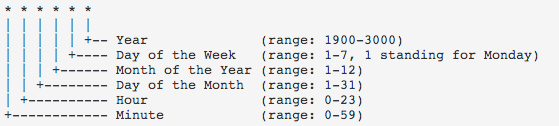 |
| msg_text | String | If your condition happens this message is sent to the user. |
| start_month | Integer | Optional. If you defined any accumulation parameter you must set this parameter. Accumulation must start from a date this indicates the month of start date. |
| start_date | Integer | Optional. If you defined any accumulation parameter you must set this parameter. Accumulation must start from a date this indicates the day of start date. |
| non_repeat | Boolean | If this is true when condition occurs notification is sent and it never checks this condition again. It is useful especially in accumulation conditions. For example, lets say our condition is GDD > 100, so when GDD is bigger than 100 system sends notification. However, at next days GDD is bigger or equal to 100 there is no need to send notification again and again. If this parameter is true, it just sends notificaion in the first occur and keep silent in the rest of the year. |
| trigger_hour | Integer | This is the hour that indicates when we want to check our rules. If we set 15, system will check rules at 15:00 UTC. |
| day_ahead | Integer | This is for hourly weather forecast check. You can check today, tomorrow, and day after tomorrow. For example you may want to get notification about tomorrow's weather alerts, then ypu should set it to 1. It can be 0,1,2. |
| is_hourly | Boolean | Normally daily weather parameters are checked, if this parameter is true, then hourly parameters will be checked and returned alert hours. |
tarlaio_service parameter explanations:
| Parameter | Type | Explanation |
|---|---|---|
| plant_id | Integer | Optional. Tarlaio contents are based on plant and location. Therefore, system needs the plant in given location. You can find plant_id's below. However if you just want to get content about weather and general agriculture tricks you can send plant_id as null also. |
| prefix | String | Optional. If you want to add prefix before content text you can give it here. |
| postfix | String | Optional. If you want to add postfix after content text you can give it here. |
// v1 result
{
  "result":"successful"
}

// v2 result
{
  "result":"successful",
  "alert_id":12
}
Explanation of alert POST body parameters:
This is explanation of a sample alert POST request to your API.
{
  "lightnings": [
    {
      "user_id": "sample_user_id",
      "lat": 39.19,
      "lng": 32.12,
      "distance": 7.97
    },
    {
      "user_id": "sample_user_id_2",
      "lat": 40.22,
      "lng": 28.11,
      "distance": 11.84
    }
  ],
  "polygons": [
    {
      "user_id": "sample_user_id",
      "severity": "High"
    },
    {
      "user_id": "sample_user_id",
      "severity": "Medium"
    }
  ],
  "weather_alerts": [
    {
      "user_id": "sample_user_id",
      "content": "Your predefined content when setting weather conditions."
    }
  ],
  "precipitations": [
    {
      "user_id": "sample_user_id",
      "direction": "north",
      "dbz": 23,
      "arrival_time": 25,
      "type": "rain"
    },
    {
      "user_id": "sample_user_id_2",
      "direction": "northeast",
      "dbz": 33,
      "arrival_time": 30,
      "type": "snow"
    }
  ],
  "tarlaio": [
    {
      "user_id": "sample_user_id",
      "content": "Your predefined content when setting weather conditions."
    },
    {
      "user_id": "sample_user_id_2",
      "content": "Your predefined content when setting weather conditions."
    }
  ],
  "all_clears": [
    {
      "user_id": "sample_user_id"
    },
    {
      "user_id": "sample_user_id_2"
    }
  ]
}
lightnings parameter explanations:
| Parameter | Type | Explanation |
|---|---|---|
| user_id | String | Id of the user that has lightning near. |
| lat | Float | Latitude of the nearest lightning. |
| lng | Float | Longitude of the nearest lightning. |
| distance | Float | Distance of the nearest lightning to user's location. Unit: km |
polygons parameter explanations:
| Parameter | Type | Explanation |
|---|---|---|
| user_id | String | Id of the user that has storm polygon near. |
| severity | String | It indicates the severity of the storm polygon. It can be "High", "Medium" or "Low". |
weather_alerts parameter explanations:
| Parameter | Type | Explanation |
|---|---|---|
| user_id | String | Id of the user that has weather alert in his location. |
| content | String | It is the text while you were setting the weather conditions. If conditions happen, user is sent in this JSON. |
precipitations parameter explanations:
| Parameter | Type | Explanation |
|---|---|---|
| user_id | String | Id of the user that has precipitation approaching to his location. |
| direction | String | Direction of the approaching precipitation. It can be "north","northeast","south","southeast","west","east","southwest","northwest". |
| dbz | Integer | Radar DBZ value of the approaching precipitation. |
| arrival_time | Integer | Approximate arrival time of the approaching precipitation. Unit: minute |
| type | String | Type of the precipitation. It can be "snow" or "rain". |
IMPORTANT NOTE: There are 2 types of approaching precipitation. First one has arrival time and second one has no arrival time. Second one actually does not mean an approaching precipitation. It just says that, you have precipitation clouds near by you be careful. They can come to your location or go away. This type of precipitation has arrival_time parameter as None.
tarlaio parameter explanations:
| Parameter | Type | Explanation |
|---|---|---|
| user_id | String | Id of the user that has tarlaio alert in his location. |
| content | String | It is the text that is created by tarlaio system. It includes dynamic or static information about agriculture. |
all_clears parameter explanations:
| Parameter | Type | Explanation |
|---|---|---|
| user_id | String | Id of the user that has all clear alert in his location. All clear means no lightnings nearby anymore. |
Alert Notification Delete
{
 "post_url": "http://sample-backend.com/nowcast",
 "post_user_id": "123456"
}

or to delete a gsm

{
 "gsm": "5551112233"
}

or to delete an email

{
 "email": "user1@domain.com"
}

***********************
FOR VERSION 2
************************
to delete a gsm you need to give path parameters like blow

https://world.tarla.io/v2/alert?gsm=5551112233&alert_id=12

https://world.tarla.io/v2/alert?email=user1@domain.com&alert_id=12
You can remove alert user from system. You can just remove your users, even another customer has same user gsm with you, system just deletes your user and do not touch other customer's user. If you try to delete a user that you do not have, api returns a response like "You do not have such user!"
Version Differences: In version 2, you can delete with your alert_id, in this way if you have same user with multiple location and just want to delete one location of that user, just give related alert_id of that location with your user info and system just deletes that location for your user. Also in version 2, parameters are path parameters so this endpoint has no JSON body in version 2!
| Base URL | https://world.tarla.io/v1/alert or https://world.tarla.io/v2/alert |
| Request Type | DELETE |
| Request Heeader | application/json |
| Response Type | Instant response |
Alert Notification Get Users
This endpoint returns specific or all alert notification users that you have. It looks your apikey and return according to that. It takes alert_name or *alert_id as path parameter. If you do not give any parameters, it returns all of your users.
| Base URL | https://world.tarla.io/v1/alert |
| Request Type | GET |
| Response Type | Instant response |
| Sample Request | https://world.tarla.io/v1/alert?alert_name=Ankara or https://world.tarla.io/v1/alert?alert_id=12 |
Explanation of response body parameters:
Successful response body
{
 "nowcast_users": [
    {
      "alert_id": 120344,
      "user_id": "15697",
      "lat": 38.47482,
      "lng": 27.0486,
      "created": "2020-11-13 20:43:34"
    },
    {
      "alert_id": 120475,
      "user_id": "1407",
      "lat": 38.4753947074411,
      "lng": 27.0484722477546,
      "created": "2020-11-14 16:04:01"
    }
  ],
  "weather_users": [
    {
      "alert_id": 120344,
      "user_id": "15697",
      "lat": 38.47482,
      "lng": 27.0486,
      "created": "2020-11-13 20:43:34"
    },
    {
      "alert_id": 120475,
      "user_id": "1407",
      "lat": 38.4753947074411,
      "lng": 27.0484722477546,
      "created": "2020-11-14 16:04:01"
    }
  ],
  "tarlaio_sms_users": [
    {
      "alert_id": 120344,
      "user_id": "15697",
      "plant_id": 83,
      "lat": 38.47482,
      "lng": 27.0486,
      "created": "2020-11-13 20:43:34"
    },
    {
      "alert_id": 120475,
      "user_id": "1407",
      "plant_id": 99,
      "lat": 38.4753947074411,
      "lng": 27.0484722477546,
      "created": "2020-11-14 16:04:01"
    }
  ]
}
Alert Notification Update Users
This endpoint is for updating weather parameters of alert notification users that you have. It takes weather_rule_id so you can update weather alert parameters of a specific user. You can find weather_rule_id from GET request.
You can update any parameter in weather_list. These are rules, cron_date, msg_text, start_month, start_date, non_repeat*. For example if you use has a rule like "temperature_max": ["down", 5] and you want to update it like above 5 temperature. Then your json body should look like this:
{ "weather_list": { "weather_rule_id": 3, "rules": { "temperature_max": [5,"up"] } } }
or you can update post_user_id by giving alert_id.
{ "alert_id": 8, "post_user_id":"test" }
| Base URL | https://world.tarla.io/v1/alert |
| Request Type | PUT |
| Response Type | Instant response |
| Sample Request | https://world.tarla.io/v1/alert |
{
    "weather_list": {
        "weather_rule_id": 3,
        "rules": {
            "precipitation": [1,1],
            "temperature_max": [2,2]
        },
        "start_month":12
}
}

or

{
    "alert_id": 8,
    "post_user_id":"test"
}
Observations
This returns observed weather parameters in given time interval for given lat,lng. It takes data from nearest weather stations from given lat,lng. null values mean no data.
| Base URL | https://world.tarla.io/v1/observations |
| Request Type | GET |
| Response Type | Instant response |
| Sample Request | https://world.tarla.io/v1/observations?lat=38.344531&lng=33.751179&start_date=2020-03-28&end_date=2020-04-02 |
| Parameter | Type | Explanation |
|---|---|---|
| lat | Float | Latitude. |
| lng | Float | Longitude. |
| start_date | String | Start date of observation data. In YYYY-MM-DD format. This day is included. |
| end_date | String | End date of observation data. In YYYY-MM-DD format. This day is included. |
Explanation of response body parameters:
Successful response body
{
  "station": {
    "lat": 38.43462,
    "lng": 33.88184,
    "distance": 15.17
  },
  "observations": [
    {
      "data_time": "2020-03-31 16:07",
      "sea_data_time": "2020-03-31 16:07",
      "humidity": 51,
      "temperature": 14.1,
      "sea_temperature": null,
      "wind_speed": null,
      "wind_direction": null,
      "actual_pressure": null,
      "sea_level_pressure": null,
      "snow_height": null,
      "precipitation_now": 0.0,
      "precipitation_10m": 0.0,
      "precipitation_1h": 0.0,
      "precipitation_6h": 0.0,
      "precipitation_12h": 0.0,
      "precipitation_24h": 0.0,
      "hadise": "Çok Bulutlu"
    },
    {
      "data_time": "2020-03-31 16:19",
      "sea_data_time": "2020-03-31 16:19",
      "humidity": 51,
      "temperature": 13.9,
      "sea_temperature": null,
      "wind_speed": null,
      "wind_direction": null,
      "actual_pressure": null,
      "sea_level_pressure": null,
      "snow_height": null,
      "precipitation_now": 0.0,
      "precipitation_10m": 0.0,
      "precipitation_1h": 0.0,
      "precipitation_6h": 0.0,
      "precipitation_12h": 0.0,
      "precipitation_24h": 0.0,
      "hadise": "Çok Bulutlu"
    },
    .
    .
    .
}
| Parameter | Type | Explanation |
|---|---|---|
| station_lat | Float | Latitude of nearest weather station. |
| station_lng | Float | Longitude of nearest weather station. |
| station_distance | Float | Distance of nearest weather station. Unit: km |
| data_time | String | Date of observed weather parameters. It is in YYYY-MM-DD format |
| sea_data_time | String | Date of observed sea weather parameters. |
| humidity | Integer | Humidity. Unit: % |
| temperature | Float | Unit: Celcius |
| sea_temperature | Float | Unit: Celcius |
| wind_speed | Float | Unit: km/h |
| wind_direction | Integer | Unit: Degree. 0 degree is south. |
| actual_pressure | Float | Unit: hPa |
| sea_level_pressure | Float | Unit: hPa |
| snow_height | Float | Unit: mm |
| precipitation_now | Float | Current precipitation. Unit: mm |
| precipitation_10m | Float | Precipitation in last 10 minutes. Unit: mm |
| precipitation_1h | Float | Precipitation in last 1 hours. Unit: mm |
| precipitation_6h | Float | Precipitation in last 6 hours. Unit: mm |
| precipitation_12h | Float | Precipitation in last 12 hours. Unit: mm |
| precipitation_24h | Float | Precipitation in last 24 hours. Unit: mm |
| hadise | String | Explanation of weather condition in text. |
Excel Report
This sends excel data reports to your email. Data can be lightning, polygon or precipitation. It takes a coordinate and time interval then send reports in xlsx format.
| Base URL | https://world.tarla.io/v1/excel/data |
| Request Type | GET |
| Response Type | Instant response |
| Sample Request | https://world.tarla.io/v1/excel/data?lat=39&lng=32&start_date=2020-04-01&end_date=2020-06-01&radius=10&is_daily_accumulation=true&data=lightning,polygon,precipitation&show_all_days=false&email=mnuri%40tarla.io |
| Parameter | Type | Explanation |
|---|---|---|
| lat | Float | Latitude. |
| lng | Float | Longitude. |
| start_date | String | Date that report starts. In YYYY-MM-DD format. |
| end_date | String | Date that report ends. In YYYY-MM-DD format. |
| radius | Integer | Indicates the area, system draws a circle with this much radius and returns number of lightnings and polygons in this drawn circle. |
| is_daily_accumulation | Boolean | If it is true, each row represents a day. If it is false, each row represents exact day, hour and minute of events. For example, lets say at 2020-05-01 there were 20 lightnings. If this parameter is true, than in excel there will be a row and it is 2020-05-01 and its value is 20. If this parameter is false, then there will be 20 rows and each rows shows properties of the lightnings. |
| show_all_days | Boolean | If it is false, just days that events occurs will be on the excel. If it is true, each day will be on the excel even if there were no events. |
| data | String | Wanted data in report. It is comma seperated list. List can take these three items: lightning,polygon,precipitation. For example: lightning,precipitation |
| String | Email address that report will be sent. |
Explanation of response body parameters:
Successful response body
{
  "result": "successful"
}
Soil Analyze
This endpoint returns some important parameters about soil like ph, water content,
clay content, organic carbon amount etc.
| Base URL | https://world.tarla.io/v1/soil/analyze |
| Request Type | GET |
| Response Type | Instant response |
| Sample Request | https://world.tarla.io/v1/excel/data?lat=39&lng=32 |
| Parameter | Type | Explanation |
|---|---|---|
| lat | Float | Latitude. |
| lng | Float | Longitude. |
Explanation of response body parameters:
Successful response body
{
  "slope_in_radians": 7,
  "surface_water_occurance_probability": 0,
  "soil_organic_carbon_content": {
    "0cm": 2,
    "10cm": 2,
    "100cm": 1,
    "200cm": 0,
    "30cm": 2,
    "60cm": 1
  },
  "soil_bulk_density": {
    "0cm": 134,
    "10cm": 134,
    "100cm": 148,
    "200cm": 149,
    "30cm": 136,
    "60cm": 144
  },
  "clay_content": {
    "0cm": 20,
    "10cm": 20,
    "100cm": 23,
    "200cm": 23,
    "30cm": 25,
    "60cm": 24
  },
  "sand_content": {
    "0cm": 39,
    "10cm": 38,
    "100cm": 36,
    "200cm": 37,
    "30cm": 36,
    "60cm": 35
  },
  "soil_texture_class": {
    "0cm": 7,
    "10cm": 7,
    "100cm": 7,
    "200cm": 7,
    "30cm": 7,
    "60cm": 7
  },
  "soil_ph": {
    "0cm": 77,
    "10cm": 77,
    "100cm": 79,
    "200cm": 79,
    "30cm": 77,
    "60cm": 78
  },
  "soil_water_content": {
    "0cm": 29,
    "10cm": 30,
    "100cm": 31,
    "200cm": 31,
    "30cm": 31,
    "60cm": 31
  }
}
| Parameter | Type | Explanation |
|---|---|---|
| slope_in_radians | Integer | Unit: radian |
| surface_water_occurance_probability | Integer | Unit: % |
| soil_organic_carbon_content | Object | Unit: 5g/kg |
| soil_bulk_density | Object | Unit: 10 kg/m3 |
| clay_content | Object | Unit: % (kg / kg) |
| sand_content | Object | Unit: % (kg / kg) |
| soil_texture_class | Object | Unit: (USDA system) . 1-Clay 2-Silt Clay 3-Sand Clay 4-Clay Loam 5-Silt Clay Loam 6-Sand Clay Loam 7-Loam 8-Silt Loam 9-Sand Loam 10-Silt 11-Loam Sand 12-Sand 255-No data |
| soil_ph | Object | Unit: ph x 10 |
| soil_water_content | Object | Field capacity. Unit: at 33kPa |
Error Codes
| Code | Explanation | Return Value |
|---|---|---|
| 403 | no permission to access | { "message": "Forbidden"} |
| 500 | a problem occured about returning data | { "message": "Error"} |
| 401 | there is no apikey parameter at header of the request | { "message": "Auth API key required."} |
| 401 | wrong apikey | { "message": "Invalid API key."} |
| 401 | apikey does not have permission to user that product | { "message": "Wrong product."} |
| 401 | apikey run out of limit for that product | { "message": API key exceeded."} |
| 401 | apikey expired | { "message": API key expired."} |
| 422 | wrong parameters in the request | JSON that has what is wrong in your request |